")


MISSION:
Support current combat operations and U.S. Army modernization through timely delivery and deployment of an array of terrestrial sensor capabilities.
VISION:
Ensure battlefield dominance by delivering the most advanced ground sensors in the world.
DESCRIPTION:
Project Manager Terrestrial Sensors leads the Army’s development, procurement, fielding, training for, and sustainment of best-in-class ground sensors that enable robust surveillance, reconnaissance, and target acquisition. In addition to delivering broad and deep subject matter expertise in sensor technologies and the associated industry partners, the PM is the Army’s primary integrator of sophisticated sensors on a myriad of Army platforms, including the Abrams Main Battle Tank, the Bradley Fighting Vehicle, the Stryker Fighting Vehicle, the future Next Generation Combat Vehicle, the Husky Mounted Detection System, various tactical aerostats, and numerous towers. Standard integration across numerous Army platforms enables both the efficacy and efficiency of sensor development, procurement, and sustainment. The PM also manages a suite of sensor-driven capabilities that directly support engineers in conducting geographical surveys and similar data gathering activities that also significantly contribute to a holistic understanding of the battlefield.
MS. LAREINA ADAMS

Ms. Lareina Adams currently serves as the Project Manager, Terrestrial Sensors for Program Executive Office Intelligence, Electronic Warfare & Sensors (PEO IEW&S).
PM Terrestrial Sensors mission is to support current combat operations and U.S. Army modernization through timely delivery and deployment of an array of terrestrial sensor capabilities. Ms. Adams was assigned to Headquarters Department of the Army Deputy Chief of Staff, G6 prior to assuming duties as the Project Manager for PM Terrestrial Sensors.
Ms. Adams other assignments include Product Manager, Counter Explosive Hazard (CEH) for PEO IEW&; Project Management and systems engineering support to Program Executive Office Enterprise Information Systems (PEO EIS), the U.S. Army Communications Electronics Command Software Engineering Center at Fort Belvoir, the Defense Information Systems Agency Global Information Grid Operations Directorate, and the U.S. Army Information Systems Engineering Command.
Ms. Adams is a 2017 graduate of the Defense Acquisition University Senior Service College Fellowship. She has received several awards during her civilian career, including the Meritorious Civilian Service Medal, Civilian Service Commendation Medal, and Achievement Medal for Civilian Service. Ms. Adams holds a Master of Science Degree in Electrical Engineering from Virginia Polytechnic Institute, is a member of the Army Acquisition Corps, and is Defense Acquisition Workforce Initiative Act (DAWIA) Level III Certified in Program Management.
MR. JERORD WILSON

Mr. Jerord “Jerry” E. Wilson is the current Deputy Project Manager, Terrestrial Sensors. Mr. Wilson currently serves as the Deputy Project Manager, Terrestrial Sensors, Program Executive Office Intelligence, Electronic Warfare & Sensors (PEO IEW&S). Mr. Wilson is responsible for the development, platform integration, upgrade, testing, fielding, and sustainment of Programs of Record (POR) and Quick Reaction Capabilities (QRCs) to meet urgent Warfighter requirements.
As an Army Officer and a Department of the Army Civilian with over 34 years of Federal Service, Mr. Wilson has held numerous key leadership positions, such as: Team Leader, Squad Leader, Platoon Leader, Airborne Infantry Assistant S-3, Airborne Infantry Rifle Company Commander, Army Infantry Branch Officer, Strategic Communication Operations Officer, Assistant Product Manager, Associate Director for Technologies/ International programs, and Deputy Product Manager. Mr. Wilson has served in two (2) combat operations, Operation Just Cause (Panama) and Operation Iraqi Freedom (OIF).
In 2017, Mr. Wilson was named one of the Command, Control, Communications, Computers, Intelligence, Surveillance and Reconnaissance (C4ISR) Top Ten Employees of the Year. His military and civilian awards include the Legion of Merit medal, Bronze Star medal, U.S. Army RANGER Tab, Army Meritorious Service Medal (4th Award), Combat Infantryman’s Badge (2nd Award), Expert Infantryman’s Badge, Airborne Badge, Air Assault Badge, Drill Sergeant Badge, the Infantry Order of Saint Maurice Medal (Centurion), and the Superior Medal for Civilian Service.
Mr. Wilson is a graduate of the U.S. Army Ranger School, the Army Civilian Advanced Course, and the Defense Acquisition University Senior Service College. He holds a Bachelor of Arts degree in Computer Information System Management from Colorado Christian University and a Master of Arts Degree in Procurement and Acquisitions from Webster University. He is DAWIA certified Level III in Project Management and Level I in Information Technology.
Mr. Wilson and his wife Jasna, reside in Alexandria, VA and have five (5) children: Vanessa, Andrej, Jordan, Alex, and Nevena.
LATEST PM TS NEWS
RESOURCES
PM TS SOCIAL MEDIA

AEROSTATS
BIOMETRICS

COMBAT TERRAIN INFORMATION SYSTEM (CTIS)

FORCE PROTECTION SYSTEMS (FPS)
COMBAT TERRAIN INFORMATION SYSTEM (CTIS)
Programs
Aerostats
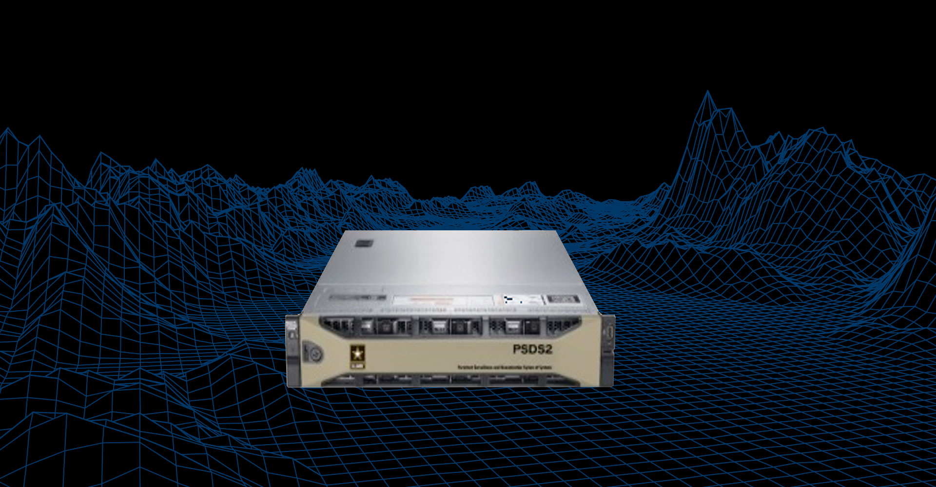
Persistent Surveillance and Dissemination System of Systems (PSDS2)
MISSION:
PSDS2 is a Full Motion Video (FMV) system and architecture that ingests video from sensors into a centralized location to support persistent surveillance, video exploitation, dissemination and archiving. PSDS2 has been fielded since 2005.
DESCRIPTION:
PSDS2 provides a sensor data management system that integrates multiple motion imagery sensors for enhanced situational awareness and rapid decision-making. PSDS2 provides real-time viewing, dissemination, archiving and exploitation for operations, intelligence and protection via a web browser thin-client user interface. PSDS2 is a Quick Reaction Capability (QRC) that has been fielded since 2005.
SYSTEM INTERDEPENDENCIES:
- PSDS2 is an architecture; it does not have direct system interdependencies
PROGRAM STATUS:
- Sustainment
PROJECTED ACTIVITIES:
- PSDS2 continues to provide support for on-going theater efforts
Persistent Surveillance and Dissemination System of Systems (PSDS2)
Persistent Surveillance System – Tethered (PSS-T) (Large and Medium)
MISSION:
PSS-T provides 360˚ detection, surveillance, monitoring, and targeting capability through real-time full motion video, Electro-Optical/Infrared (EO/IR), and wide area detection of moving vehicles, and dismount targets.
DESCRIPTION:
The PSS-T Family of Systems (FoS) offers medium and large aerostat systems to meet future expeditionary and contingency requirements for persistent surveillance, information collection, force protection enhancement, and Army Aerial Layer Network Transport. The PSS-T FoS provides persistent, integrated, networked, and multi-sensor information collection by operating for long periods of time at an altitude to maximize 360-degree line of sight in area of operations. The PSS-T FoS is a highly persistent and flexible multi-sensor information collection system that is capable of detecting hostile fire, providing target coordinates to appropriate command and control/fire control centers, and marking ground targets for rapid engagement as well as offering high altitude radio communication extension for extended communication beyond the line of sight. The PSS-T FoS provide weather-dependent, continuous support throughout the joint operational area, that can be integrated with other aerial and unattended ground sensor systems to provide slew-to-cue capability and directly enhancing a commander’s situational understanding.
PSS-T FoS have demonstrated signal intelligence (SIGINT), EW, counter-unmanned aerial systems (C-UAS) and tracking radar improvements based on increased line of sight from Aerostats.
SYSTEM INTERDEPENDENCIES:
- The use of electro optical infrared (EO/IR) and other available payload sensors, enables the aerostat system to execute in accordance with passive and dynamic operational requirements.
PROGRAM STATUS:
- Post Milestone C – Fielding to support existing and emerging requirements
PROJECTED ACTIVITIES:
- Continue to support requirements in CENTCOM; working requirements in EUCOM
- Development of future exercises with 10th MTN, 101st ARB Space Command, and OUSD
Persistent Surveillance System – Tethered (PSS-T) (Large and Medium)

Biometrics
DoD Automated Biometric Identification System (ABIS)
MISSION:
DoD ABIS is a system that collects, stores, matches, and shares biometric data (such as fingerprints, palm prints, iris scans, and facial scans) from persons of interest globally. It is used to identify and verify potential threats to national security and support military operations. It provides 24/7 operational support and uses specialized software and biometric examiners for manual matching12.
DESCRIPTION:
Biometrics matching capabilities allow the Warfighter to accurately identify, target, deny access, and/or detain known or suspected adversaries around the globe. To support this mission, DoD ABIS serves as the authoritative repository for biometrics data collected from known and suspected terrorists and persons of interest. It is used by all the Services, Geographic Combatant Commands, Special Operations forces, and the Intelligence Community. The current DoD ABIS v1.3 system matches, stores, and shares four biometric modalities: fingerprint, facial images, palm-print, and iris patterns. The next generation DoD ABIS v2.0 will add the voice modality. The system enables force protection, intelligence, physical and logical access control, identity management, and detection and interception operations. It features integrated commercial-off-the-shelf (COTS) and Government-off-the-shelf (GOTS) products, using open architecture to minimize development and speed deployment. DoD ABIS interfaces with numerous DoD and interagency biometrics systems, including Department of Justice (DoJ), Federal Bureau of Investigation (FBI), Department of Homeland Security (DHS), and Department of State (DoS).
SYSTEM INTERDEPENDENCIES:
- DoD ABIS interfaces with other government agencies, partner nations, and physical access control systems (PACS) at military installations to obtain and share biometric data
PROGRAM STATUS:
- BEC 1 program for development of next generation DoD ABIS v2.0 achieved successful Milestone B decision in JAN 22
- Awarded new contract for continued DoD ABIS sustainment and next generation development in JUN 22
- Received 2022 Best Technical Advancement Award for new DoD ABIS Watch Listing Capability at Federal Identity Conference in SEP 22
PROJECTED ACTIVITIES:
- DoD ABIS first “Capability Drop” of system enhancements planned for deployment not later than 4Q FY24
Biometrics Enabling Capability (BEC 0)
MISSION:
PdM BEC is responsible for life-cycle sustainment and next generation development of the Department of Defense Automated Biometrics Identification System (DoD ABIS)—the authoritative DoD repository for biometrics data collection, storage, matching, and sharing.
DESCRIPTION:
Biometrics matching capabilities allow the Warfighter to accurately identify, target, deny access, and/or detain known or suspected adversaries around the globe. To support this mission, DoD ABIS serves as the authoritative repository for biometrics data collected from known and suspected terrorists and persons of interest. It is used by all the Services, Geographic Combatant Commands, Special Operations forces, and the Intelligence Community. The current DoD ABIS v1.3 system matches, stores, and shares four biometric modalities: fingerprint, facial images, palm-print, and iris patterns. The next generation DoD ABIS v2.0 will add the voice modality. The system enables force protection, intelligence, physical and logical access control, identity management, and detection and interception operations. It features integrated commercial-off-the-shelf (COTS) and Government-off-the-shelf (GOTS) products, using open architecture to minimize development and speed deployment. DoD ABIS interfaces with numerous DoD and interagency biometrics systems, including Department of Justice (DoJ), Federal Bureau of Investigation (FBI), Department of Homeland Security (DHS), and Department of State (DoS).
SYSTEM INTERDEPENDENCIES:
- NGIC Biometric Identity Intelligence Resource (BI2R); Biometrics Automated Toolset – Army (BAT-A); Next Generation Biometrics Collection Capability (NXGBCC); Near Real Time Identity Operations (NRTIO); Navy Identity Dominance System (IDS); SOCOM Special Operations Forces Exploitation Portal (SOFEX); EUCOM DEX Portal; USMC Identity Dominance System-Marine Corps (IDS-MC); FBI Next Generation Identification (NGI); DHS Automated Biometric Identification System (IDENT)
PROGRAM STATUS:
- BEC 0 – Post Milestone C ACAT III program in sustainment
- BEC 1 – Post Milestone B ACAT III program
PROJECTED ACTIVITIES:
- BEC 1 – Full Deployment Decision FY24
Biometrics Enabling Capability (BEC 1)
MISSION:
The Product Lead, Biometrics Enabling Capability (PL BEC), is responsible for sustaining the DoD Automated Biometrics Identification System (DoD ABIS) and developing new capabilities to support the DoD Biometrics Enterprise. DoD ABIS is the authoritative DoD biometrics repository supporting the identification of known or suspected adversaries around the globe by DoD, the Intelligence Community, and Interagency partners through the sharing of biometrics and the Defense Watch List (DWL).
DESCRIPTION:
BEC 1 is the Program of Record for DoD ABIS v2.0 fielded through nine incremental deployments which were completed in FY24 as part of the ACAT III BEC Increment 1 Post-MS B Program. DoD ABIS v2.0 followed a Base-Case-Enhanced evolutionary acquisition program strategy, building upon the existing version 1.3 system and an Information Technology (IT) Box concept. This acquisition strategy provided flexibility to incrementally develop and field DoD the ABIS v2.0 capability through planned Capability Drops (CDs) based on requirement refinement, funding availability, and technological advances. DoD ABIS v2.0 CD 1 migrated the DoD ABIS to the Amazon Web Services (AWS) GovCloud and added the voice modality. DoD personnel operating in every geographic combatant command can now access and submit biometrics data to DoD ABIS anywhere in the world.
SYSTEM INTERDEPENDENCIES:
-
BEC 1 is the Program of Record for DoD ABIS v2.0 fielded in FY24. As such, BEC 1 is a GovCloud system interfacing with other U.S. Government databases supporting the DoD, Interagency partners, and foreign allies.
PROGRAM STATUS:
-
Operations and Support Phase
PROJECTED ACTIVITIES:
- BEC 1 – Full Deployment Decision FY25
- Deploy a GovCloud Secure File Transfer Protocol (SFTP) solution FY25
- Review and deploy updated improved technological enhancements to the system
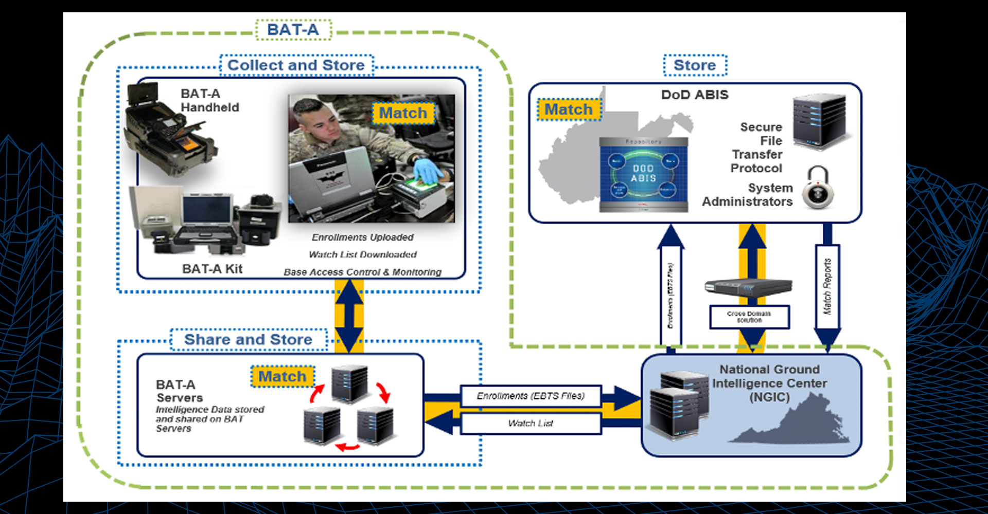
Biometrics Automated Toolset – Army (BAT-A)
MISSION:
Collects, stores, matches, shares, and analyzes biometric, biographical, and contextual data; used in five combatant commands. This capability supports the Army Force Protection and Identity Dominance Missions and sees continued service.
DESCRIPTION:
BAT-A is a multimodal biometric enrollment and identification system designed to support identity management missions; namely the BAT-A Kit and the BAT-A Hand Held (BAT-A HH). The BAT-A system consists of biometric enrollment laptops, peripherals, and BAT-A servers. BAT-A is a biometric system operated over SIPRNET. BAT-A also has a BAT.Web interface to provide worldwide access to the BAT-A data.
BAT-A HH is an all-in-one multimodal biometric enrollment and identification system designed to support identity management missions in an unclassified environment. The BAT-A HH system consists of the Secure Electronic Enrollment Kit (SEEK II) which provides fingerprint scanning, iris capture, face capture, GPS location and text input.
The BAT-A Kit collects, matches, stores, and shares a person’s biometric data and enrolls the information into the DoD enterprise authoritative biometric database, DoD Automated Biometric Identification System (DoD ABIS), to verify the individual’s identity.
SYSTEM INTERDEPENDENCIES:
- BAT-A is interface with the National Ground Intelligence Center and the DoD Automated Biometrics Identification System (DoD ABIS)
PROGRAM STATUS:
- Post Milestone-C – In Sustainment
PROJECTED ACTIVITIES:
- FY29 – End of Useful Life
Biometrics Automated Toolset – Army (BAT-A)
Near Real Time Identity Operations (NRTIO)
MISSION:
Provide the ability to collect, store, and match biometrics for individuals within the USCENTCOM Area of Responsibility (AOR) with a maximum three (3) minute response back to the tactical user, often in high threat tactical environments.
DESCRIPTION:
NRTIO is a Family of Systems (FoS) that has the capability to collect, match, and store palm, fingerprints, iris, and faces to establish identity superiority and maintain identity dominance in all areas of military operations. The purpose of the system is to positively identify individuals and link individuals to events and activities that pose a threat to peace and security, and in addition, to share biometric data with approved DoD, interagency, and multi-national partners. Key components of the system include biometric collection devices, data communications platforms, and a regional server with a web portal user interface.
SYSTEM INTERDEPENDENCIES:
- NRTIO interfaces with DoD Automated Biometrics Identification System (ABIS)
PROGRAM STATUS:
- Quick Reaction Capability
PROJECTED ACTIVITIES:
- 1Q/2Q FY25 – Technically Refreshed Mobile and Static fielding to Operation Inherent Resolve
Gate Keeper on the Move - Biometrics (GOTM-B)
MISSION:
Improve force protection posture by increasing throughput rate and improving identity operations at entry control points.
DESCRIPTION:
Physical Access Control System with contact-less biometrics (face, fingers, and iris) sensors as a standalone capability or integrated into a 20-foot CONEX container for rapid and non-stop identification and matching of personnel against the DoD Biometric Enabled Watch List.
SYSTEM INTERDEPENDENCIES:
- GOTM-B interoperates with several government systems and databases
PROGRAM STATUS:
- Quick Reaction Capability
PROJECTED ACTIVITIES:
- In Sustainment
Video Identity Collection and Exploitation (VICE)
MISSION:
Provide a robust face collection and exploitation capability that matches against known unclassified media.
DESCRIPTION:
Software solution that provides a face matching capability supporting the identification of individuals leveraging content from social media, dark web sources, captured enemy material, and manual photo/video uploads.
SYSTEM INTERDEPENDENCIES:
- N/A
PROGRAM STATUS:
- Quick Reaction Capability
PROJECTED ACTIVITIES:
- Quick Reaction Capability
Voice Identity Biometrics Exploitation Services (VIBES)
MISSION:
Provide a robust voice collection and exploitation capability that matches against known unclassified media.
DESCRIPTION:
Software solution that provides a voice matching capability supporting the identification of individuals through quality active and passive voiceprints that are either collected or extracted from videos.
SYSTEM INTERDEPENDENCIES:
- N/A
PROGRAM STATUS:
- Quick Reaction Capability
PROJECTED ACTIVITIES:
- In Sustainment
Combat Terrain Information System (CTIS)
Global Positioning System – Survey (GPS-S)
MISSION:
GPS-Survey (GPS-S) supports Technical Engineer (MOS 12T) accomplishment of construction and topographic surveys with centimeter level precision and has integrated SAASM capability that satisfies OSD Policy for operations in degraded and contested environments.
DESCRIPTION:
GPS-S enables Engineer Survey & Design and Army Dive Teams to develop accurate position location and surface profiles to support critical safety of navigation, obstacle and sensor placement, runway layout and repair, construction and maintenance, hydrographic/topographic surveys that feed planning and analysis tasks for maneuver forces. This equipment is foundational to Army Technical Engineers (MOS 12T) and Army Divers (MOS 12D) METL.
SYSTEM INTERDEPENDENCIES:
- GPS-S interfaces with current Army Survey equipment to perform integrated GPS/optical surveys and with the Instrument Set, Reconnaissance and Surveying (ENFIRE) tablet PC for post processing of survey data and import of survey design files
PROGRAM STATUS:
- Post Milestone C
PROJECTED ACTIVITIES:
- Fieldings
Global Positioning System – Survey (GPS-S)
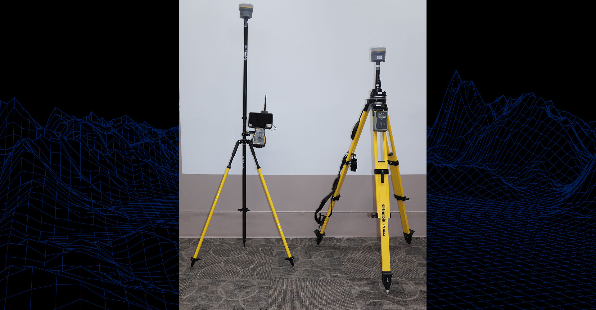
Instrument Set, Reconnaissance and Surveying (Common Name: ENFIRE)
MISSION:
Instrument Set, Reconnaissance and Surveying (common name: ENFIRE) is a digital technology upgrade to the analog Survey Set, Military Field Sketching legacy capabilities. ENFIRE enables the performance of reconnaissance, construction management, project management, field surveying, facilities management, inventory management, obstacle planning and field engineering tasks by soldiers in CMF 12. The set utilizes standard military communications devices to transfer data files to the Army Mission Command suite of warfighting capabilities.
DESCRIPTION:
ENFIRE enables maneuver forces by expediting hasty/deliberate route, area, and zone reconnaissance, route clearance, hazard identification, inventory, and construction management efforts through the integration of digital tools into a single platform. ENFIRE has evolved into the common computing platform for the Regiment enabling reconnaissance, route clearance, obstacle planning/reporting, construction management, survey support and terrain shaping and analysis.
SYSTEM INTERDEPENDENCIES:
- N/A
PROGRAM STATUS:
- Post Milestone C
PROJECTED ACTIVITIES:
- System Upgrades
- Fieldings
Instrument Set, Reconnaissance and Surveying (Common Name: ENFIRE)
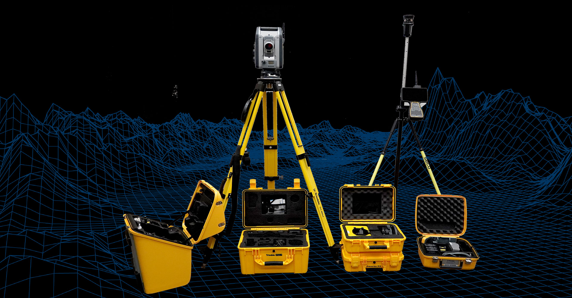
The Automated Integrated Survey Instrument (AISI)
MISSION:
The Automated Integrated Survey Instrument (AISI) is a non-developmental item (NDI) used to collect, store, retrieve, and process survey data. It is a COTS advanced surveying instrument that combines traditional land survey tools into a single auto-tracking, robotic 3D scanning total station which affords efficiency of effort that leads to less time on target. AISI can be used with other collection devices, such as GPS and HD LiDAR Scanners further enhancing analysis and utility of the collected data. This equipment is foundational for Army Technical Engineers (MOS 12T) METL.
DESCRIPTION:
AISI provides the military surveyor with a single instrument (total station) to achieve all functions formally carried out with theodolites, tapes, and distance measuring devices significantly increases the speed of survey operations and mitigation of human recording and computing errors. It automatically stores field survey data for integration to Computer Aided Design (CAD) systems.
SYSTEM INTERDEPENDENCIES:
- Interoperable with Global Positioning System – Survey (GPS-S) and ENFIRE
PROGRAM STATUS:
- Post Milestone C
PROJECTED ACTIVITIES:
- Sustainment (fieldings completed)
The Automated Integrated Survey Instrument (AISI)
Force Protection Systems (FPS)
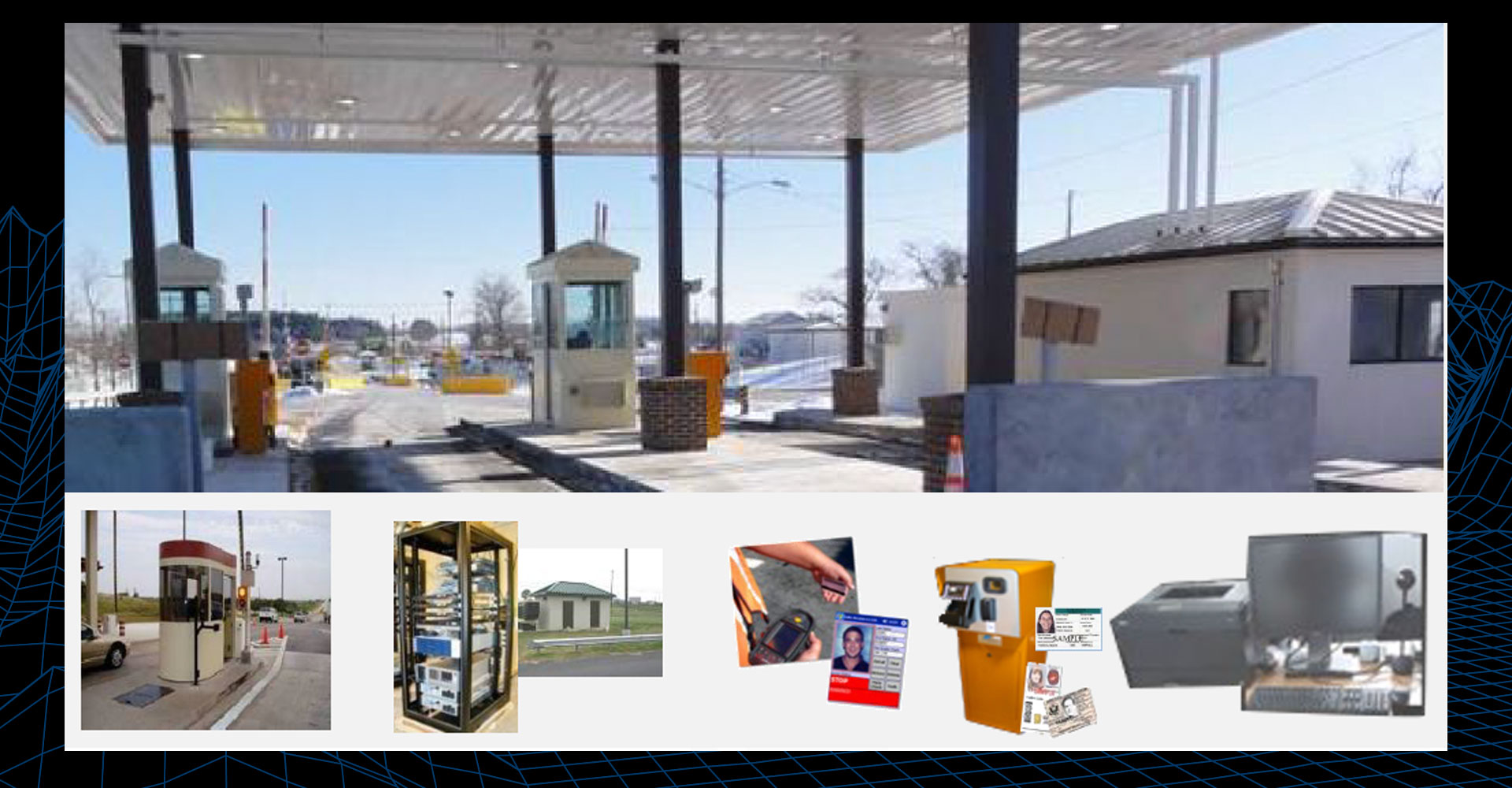
Automated Installation Entry (AIE)
MISSION:
AIE enhances Installation security through automated personnel verification and authentication using a Joint Service Architecture and authoritative databases to continuously vet personnel against possible criminal, terrorist and insider threats
DESCRIPTION:
AIE enhances security through credential verification and authentication, personnel vetting and establishing permissions for Army Installation access control. It provides continuous vetting of credentials against Federal authoritative databases and data sharing among Army Installations, Joint Services and other agencies. It has a scalable architecture to accommodate small, medium, and large sites.
SYSTEM INTERDEPENDENCIES:
- Various authoritative databases
PROGRAM STATUS:
- Production and Deployment Phase 4: Business System Acquisition, Testing & Deployment
PROJECTED ACTIVITIES:
- Continued fields to locations on the Army Priority List (APL)
- AIE is planning to field at an additional 92+ locations in the EUCOM and INDO-PACOM AORs and CONUS under the AIE-Next contract
- Upgrades (AIE-Next)
Automated Installation Entry (AIE)
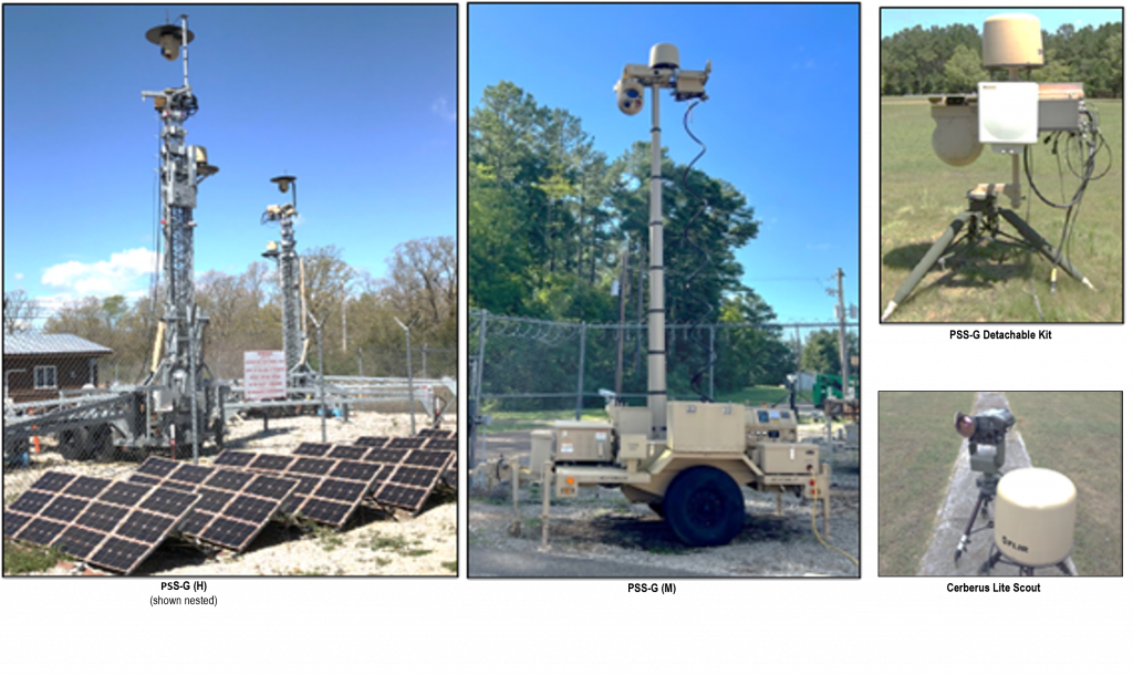
Base Expeditionary Targeting Surveillance Systems – Combined (BETSS-C)
MISSION:
BETSS-C delivers an elevated surveillance system providing 24/7, 360° visual coverage with Electro-Optical/Infrared (EO/IR) cameras for detection and assessment of potential threats.
DESCRIPTION:
- BETSS-C is a family of elevated long range surveillance systems providing 24/7, 360° visual coverage with Electro-Optical and Infrared Sensor cameras, and radars allowing detection and assessment of ground-based targets with integrated slew to cue capabilities.
- The BETSS-C family includes:
- Persistent Surveillance System-Ground (PSS-G) Heavy
- PSS-G Medium
- PSS-G Detachable Kit
- Cerberus Lite Scout
SYSTEM INTERDEPENDENCIES:
- N/A
PROGRAM STATUS:
- Sustainment
PROJECTED ACTIVITIES:
- Continued system sustainment and support for emerging requirements
Base Expeditionary Targeting Surveillance Systems – Combined (BETSS-C)
Counter Vehicle-Borne Improvised Explosive Device (C-VBIED)
MISSION:
To provide an advanced suite of Entry Control detection sensing technologies to alert Security Personnel to the presence of Vehicle-Borne IED (VBIED) and materials of interest (MOI) that threaten bases, forward operating bases, and critical infrastructure.
DESCRIPTION:
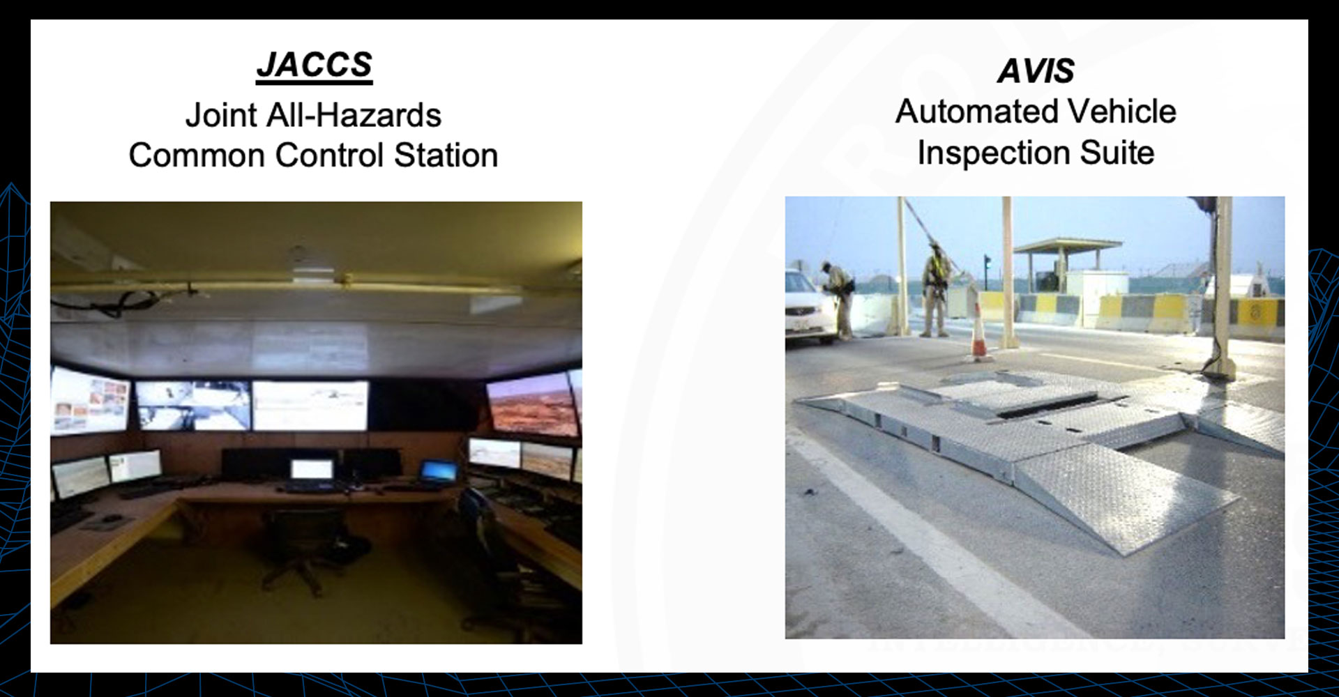
CVBIED is a System of Systems (SoS) developed to provide early vehicle-borne improvised explosive device (VBIED) detection prior to entry into Forward Operating Bases (FOBs).
As a System of Systems, C-VBIED integrates with the following systems to provide security at forward operating bases:
- Automated Vehicle Inspection System (AVIS): Enhanced optical inspection system for the underside of vehicles (Under Vehicle Inspection System) with integrated license plate reader (Automatic License Plate Reader or ALPR) and facial detection cameras (DriverCam high resolution image system)
- Joint All-Hazards Common Control System (JACCS): Provides Integrated C2 capability over Integrated Sensor Architecture (ISA) for portfolio systems, barriers, and EO/IR Camera sensors
- Optional Biometrics Enabled Watch List (BEWL) integration for facial recognition and comparison against known watch list.
SYSTEM INTERDEPENDENCIES:
- N/A
PROGRAM STATUS:
- Sustainment
PROJECTED ACTIVITIES:
- Continued system sustainment and support for emerging requirements
Counter Vehicle-Borne Improvised Explosive Device (C-VBIED)
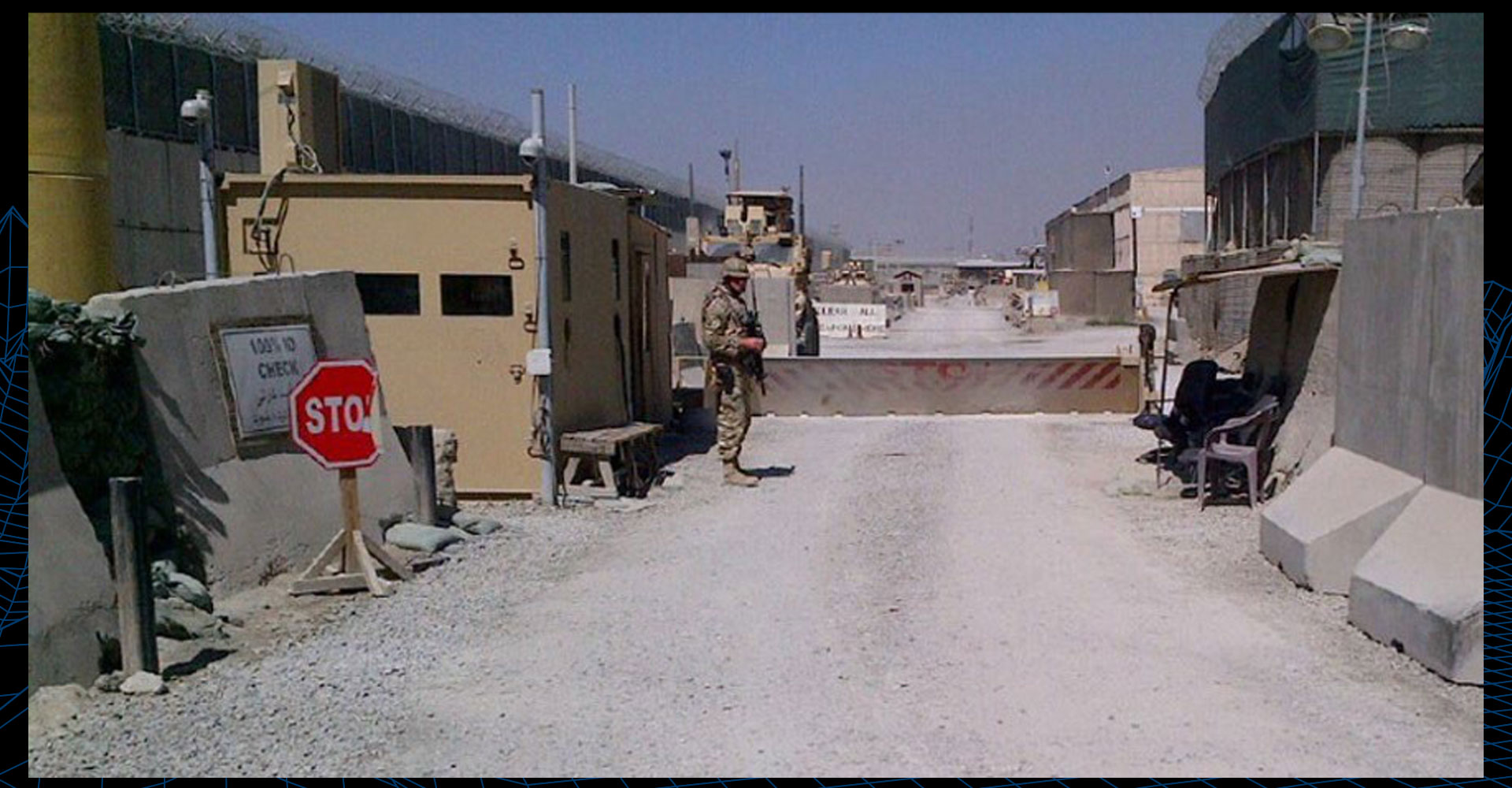
Entry Control Point (ECP)
MISSION:
To enhance base protective posture, assess threats, deny enemy access, and provide stand-off by controlling vehicle and personnel access through a system of systems approach.
DESCRIPTION:
ECP is an integrated system of systems used to protect and enhance Force Protection capability against Vehicle Borne Improvised Explosive Devices, Personnel Borne Improvised Explosive Devices, Chemical, and Direct and Indirect Fire threats at Entry Control Points to Forward Operating Bases.
SYSTEM INTERDEPENDENCIES:
- N/A
PROGRAM STATUS:
- Sustainment
PROJECTED ACTIVITIES:
- Continued system sustainment and support for emerging requirements
Entry Control Point (ECP)
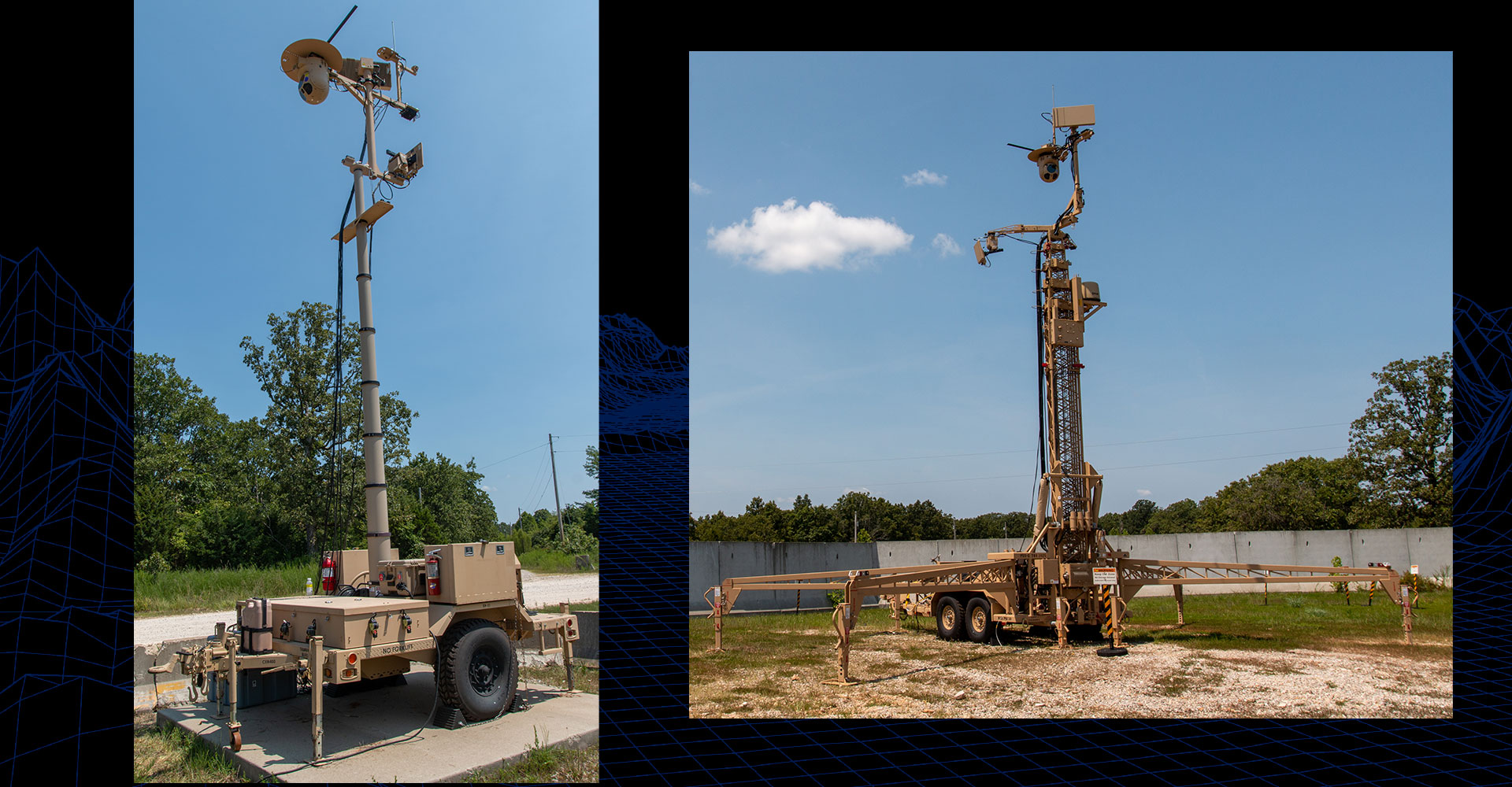
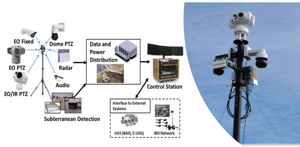
Ground-Based Operational Surveillance System (Expeditionary) (G-BOSS(E))
MISSION:
G-BOSS(E) is an expeditionary, ground-based, self-contained, multi-spectral sensor, persistent surveillance system used to observe, collect, detect, classify, identify, track, record, and report on contacts, objects of interest, and assessed threats twenty-four hours a day utilizing a fused video and sensor data display. The expeditionary nature is a critical aspect of the G-BOSS(E) to meet joint operations.
DESCRIPTION:
G-BOSS(E) is a Family of Elevated Persistent Surveillance Tower Systems based upon previously fielded Quick Reaction Capabilities (QRCs), with improved persistent surveillance detection capabilities and network integration utilizing two modular configurations and variants – Medium (Mid-sensor height (6m) for small-medium size Operating Bases/Outposts) and Heavy (High-sensor height (25m) for large Operating Bases). It operates in a stand-alone mode or as part of an integrated network and is easily operated and maintained. It is also rugged enough to support employment in expeditionary operations worldwide.
G-BOSS(E) operates in stand-alone mode or as part of an integrated network utilizing government furnished/licensed software; is integrated with current mission command systems; and is interoperable with the Security Surveillance System (SSS), Boomerang, and the Integrated Sensor Architecture.
SYSTEM INTERDEPENDENCIES:
- N/A
PROGRAM STATUS:
- Production and Deployment (P&D)
PROJECTED ACTIVITIES:
- Training and fielding of 51 systems to MP Battalions
Ground-Based Operational Surveillance System (Expeditionary) (G-BOSS(E))
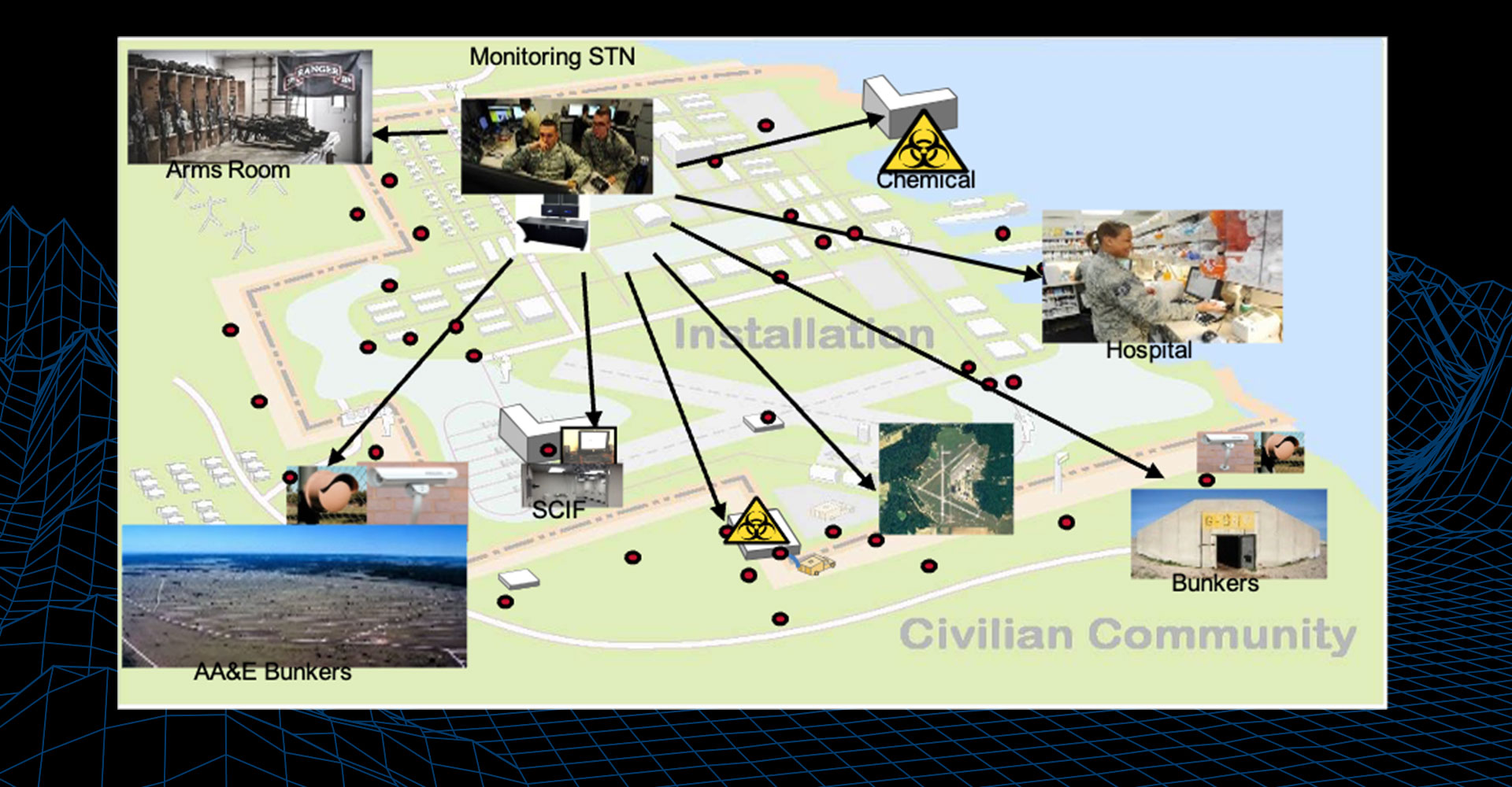
Integrated Base Defense-Kitting (IBD-K)
MISSION:
IBD-K provides an integrated Force Protection System of Systems that enhance a Unit’s protective posture and situational awareness by providing tailorable (a la carte) and layered sensor coverage. IBD-K provides Commanders with near-real-time threat detection assisting in facilitating coordinated, rapid responses to detected threats.
DESCRIPTION:
IBD-K is an integrated Force Protection System of Systems Quick Reaction Capability that addresses the five IBD construct core capabilities of perimeter security, entry control, persistence surveillance, C2 data fusion, and warn and alert.
As a System of Systems, IBD-K provides an integrated force protection capability comprised of the following equipment:
- Perimeter Security: Closed Circuit Television (CCTV) with infrared (IR) capability, Pan-Tilt-Zoom (PTZ) cameras with IR capability, Long Range Thermal Imagers (LRTI), Battlefield Anti-Intrusion System (BAIS)
- Entry Control: Portable Barriers, Ballistic Booths, Cameras, Non-Intrusive Inspection Systems, Turnstiles, 2-Way Audio
- Persistent Surveillance: BETSS-C
- C2 Data Fusion: Joint All-Hazards Common Control System (JACCS)
- Warn and Alert: Long Range Acoustic Device (LRAD), Joint Chemical Agent Detector (JCAD)
SYSTEM INTERDEPENDENCIES:
- N/A
PROGRAM STATUS:
- Sustainment
PROJECTED ACTIVITIES:
- Continued system sustainment and support for emerging requirements
Integrated Base Defense-Kitting (IBD-K)
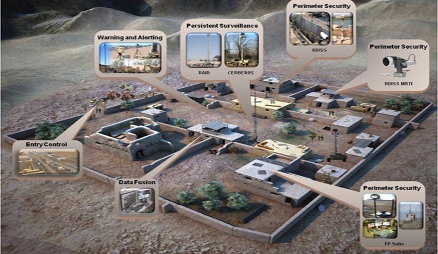
Integrated Commercial Intrusion Detection System (ICIDS)
MISSION:
ICIDS provides a standard intrusion detection capability for DoD facilities world-wide including conventional, nuclear, and chemical sites.
DESCRIPTION:
ICIDS is a highly secure, standardized Intrusion Detection System using state-of-commercial technology to detect and assess unauthorized intrusion of protected areas. ICIDS provides real-time assessment and rapid flexible response to existing, imminent, or emerging threats. ICIDS is based on a scalable architecture designed to accommodate a set quantity of protected zones within the installation.
SYSTEM INTERDEPENDENCIES:
- N/A
PROGRAM STATUS:
- Production and Deployment (P&D)
PROJECTED ACTIVITIES:
- ICIDS is scheduled to field to 15 Installations to include U.S. Army Garrisons within INDO-PACOM and EUCOM in FY25-26
Integrated Commercial Intrusion Detection System (ICIDS)
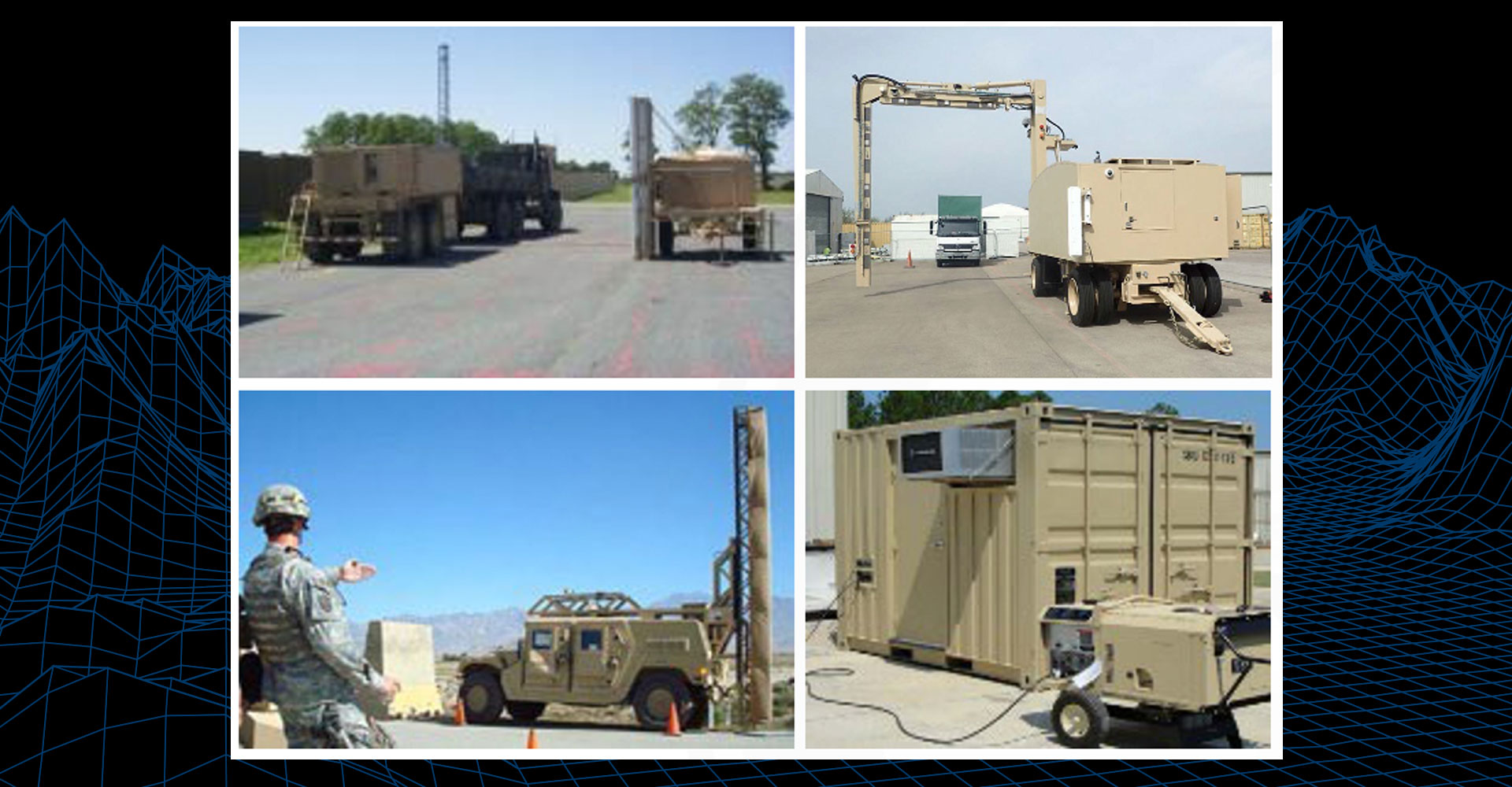
Non-Intrusive Inspection Systems (NIIS)
MISSION:
To enhance Force Protection against Vehicle and Personnel Improvised Explosive Devices, weapons, hidden personnel, narcotics, and other contraband in response to multiple Joint Urgent Operational Needs (JUONs) and Operational Needs Statement (ONS).
DESCRIPTION:
NIIS is a family of detection and screening systems for scanning personnel, vehicles, and containers providing increased probability of detection of anomalies indicating the presence of explosives, weapons, or other contraband.
SYSTEM INTERDEPENDENCIES:
- N/A
PROGRAM STATUS:
- Sustainment
PROJECTED ACTIVITIES:
- Continued system sustainment and support for emerging requirements
Non-Intrusive Inspection Systems (NIIS)
Rapid Deployment Integrated Surveillance System (RDISS)
MISSION:
RDISS provides an easy to install, operate, and maintain, rapidly relocatable base defense camera system for increased detection, assessment, and persistent surveillance.
DESCRIPTION:
RDISS is an easily transportable, flexible, scalable, expeditionary video surveillance system (Closed Circuit and Pan-Tilt-Zoom) providing outside the perimeter detection and assessment capabilities for Joint Security Sites, Combat Outposts, and Forward Operating Bases.
SYSTEM INTERDEPENDENCIES:
- N/A
PROGRAM STATUS:
- Sustainment
PROJECTED ACTIVITIES:
- Continued system sustainment and support for emerging requirements
Rapid Deployment Integrated Surveillance System (RDISS)
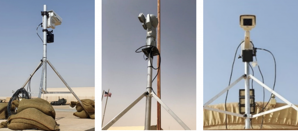
Security Surveillance System (SSS)
MISSION:
SSS missions include but are not limited to: Internment/Resettlement (I/R) operations; perimeter security; internal security areas within baåse camps or installations; outside the perimeter, border, or boundary; primary and high priority routes; route clearance; Homeland Security missions; and any named areas of interest (NAI), or other missions as directed by the Commander.
DESCRIPTION:
The SSS is a modular, scalable, lightweight, rapidly deployable, ground-based security and Surveillance System of Systems providing short and long-term security and persistent surveillance. SSS and its components are designed to be employed as a stand-alone system, in a layered effort, or integrated with additional Force Protection (FP) systems.
While SSS is designed to be employed as a stand-alone system, it can also be used in a layered effort or integrated with additional Force Protection systems.
SYSTEM INTERDEPENDENCIES:
- SSS uses an Integrated Sensor Architecture (ISA) for internal and external communications, interfaces with motion, acoustic, and seismic detection systems. The Linear Sensing System (LSS) is integrated into SSS. SSS is interoperable with the Ground-Based Operational Surveillance System (Expeditionary) (G-BOSS(E))
PROGRAM STATUS:
- Production and Deployment (P&D)
PROJECTED ACTIVITIES:
- Training and fielding of 14 systems to MP Battalions
Security Surveillance System (SSS)
Ground Sensors (GS)
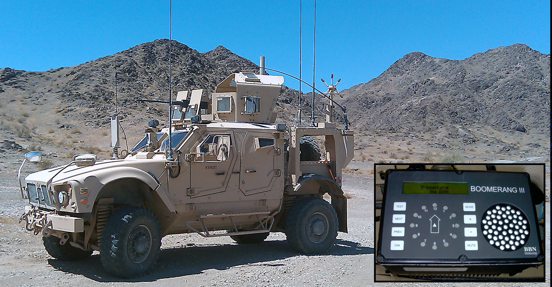
Boomerang Generation III (BG III)
MISSION:
The BG III detects incoming gunshot events and provides audible and visual identification of the shooter location (azimuth, range and elevation) to the soldier for a tactical response.
DESCRIPTION:
The BG III is a passive acoustic gunshot detection system that uses a bullet’s shockwave (crack) and muzzle blast (bang) to determine the relative position of the shooter. A heptahedral array of microphones on a mast that calculates incoming shot locations through software housed in the display unit.
SYSTEM INTERDEPENDENCIES:
- N/A
PROGRAM STATUS:
- Sustainment
PROJECTED ACTIVITIES:
- Sustainment
Boomerang Generation III (BG III)
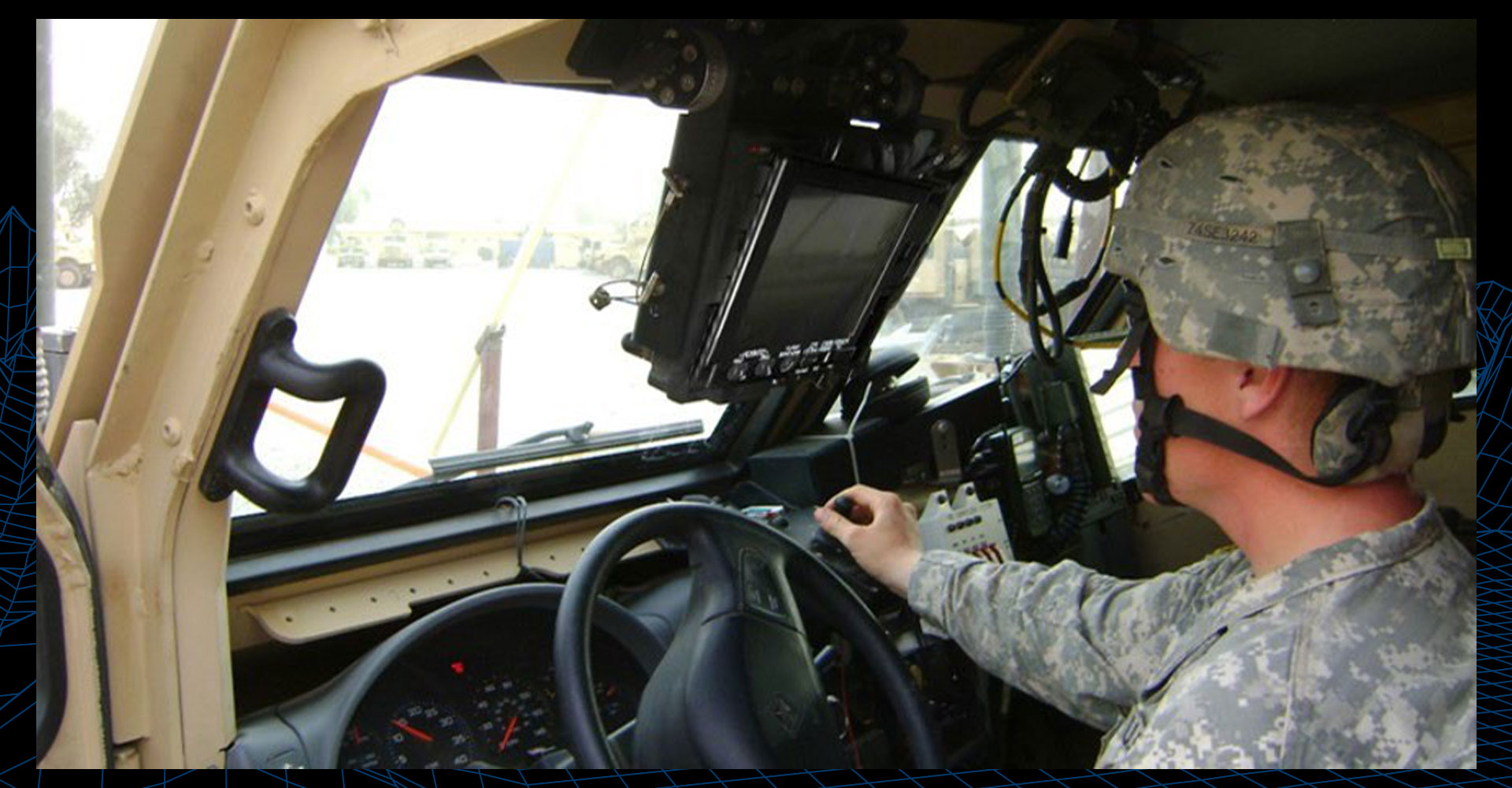
Driver’s Vision Enhancer (DVE)
MISSION:
The DVE allows for tactical vehicle movement in support of operational missions in all environmental conditions (day/night and all weather and battlefield obscurants).
DESCRIPTION:
The DVE is an uncooled thermal imaging systems for driving Combat Vehicles (CV) and Tactical Wheeled Vehicles (TWV) during limited visibility conditions (darkness, smoke, dust, fog, etc).
SYSTEM INTERDEPENDENCIES:
- DVE is within combat, tactical-wheeled vehicles, armored security vehicles, and standard security vehicles
PROGRAM STATUS:
- Operations and Support
PROJECTED ACTIVITIES:
- Operations and Support
Driver’s Vision Enhancer (DVE)
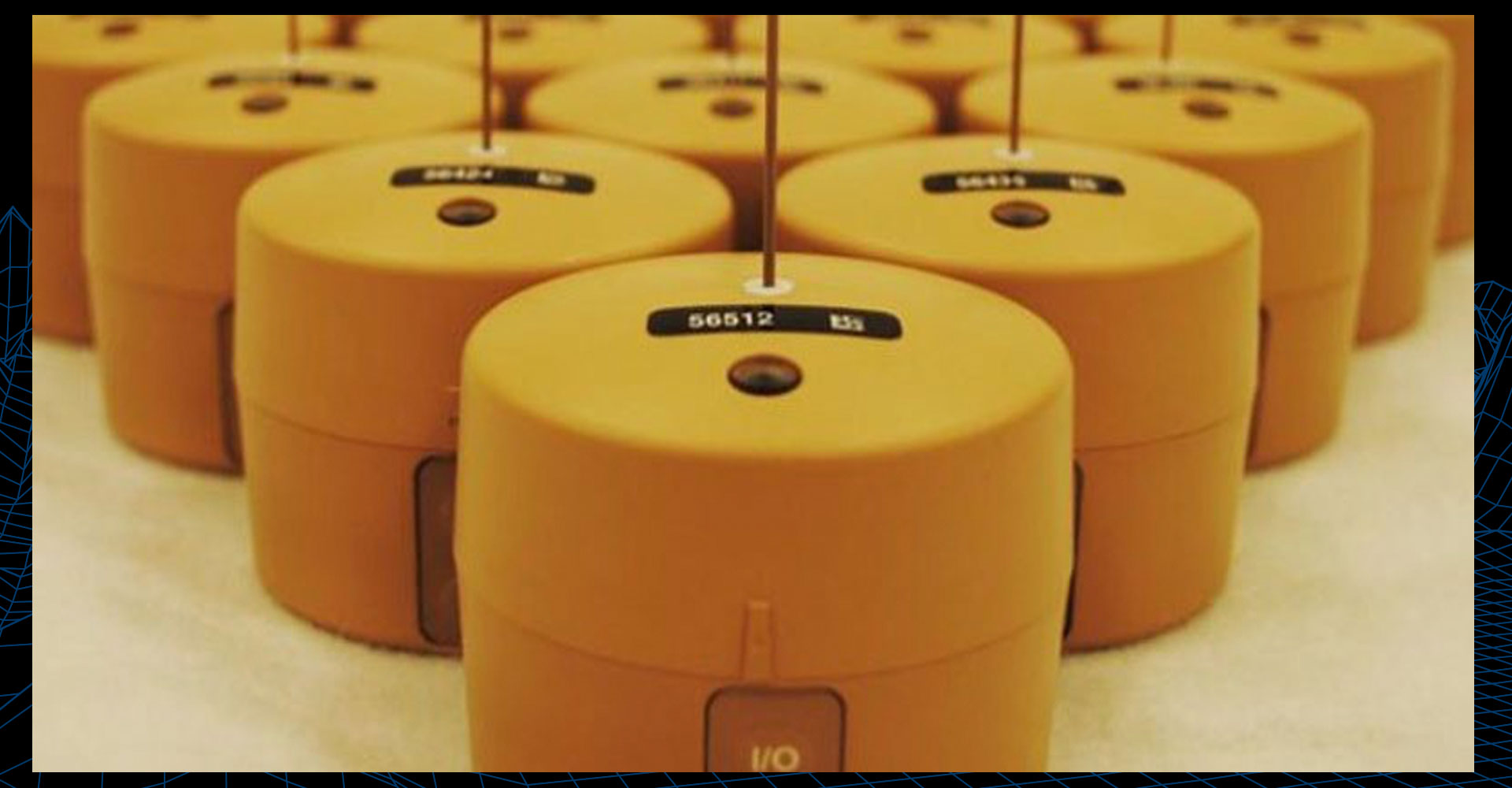
Expendable-Unattended Ground Sensor (E-UGS)
MISSION:
The E-UGS detects enemy vehicle and footstep traffic to provide improved situational awareness, enhance existing Intelligence, Surveillance and Reconnaissance (ISR) assets, and facilitate a tactical response.
DESCRIPTION:
The E-UGS is a near real-time situational awareness system that is simple to deploy, operate, and transport, with the capability to seismically detect and report human footsteps or moving vehicles. The system consists of a Base Station Kit and Sensor Kit containing 55 expendable sensors.
SYSTEM INTERDEPENDENCIES:
- N/A
PROGRAM STATUS:
- Sustainment
PROJECTED ACTIVITIES:
- Sustainment
Expendable-Unattended Ground Sensor (E-UGS)
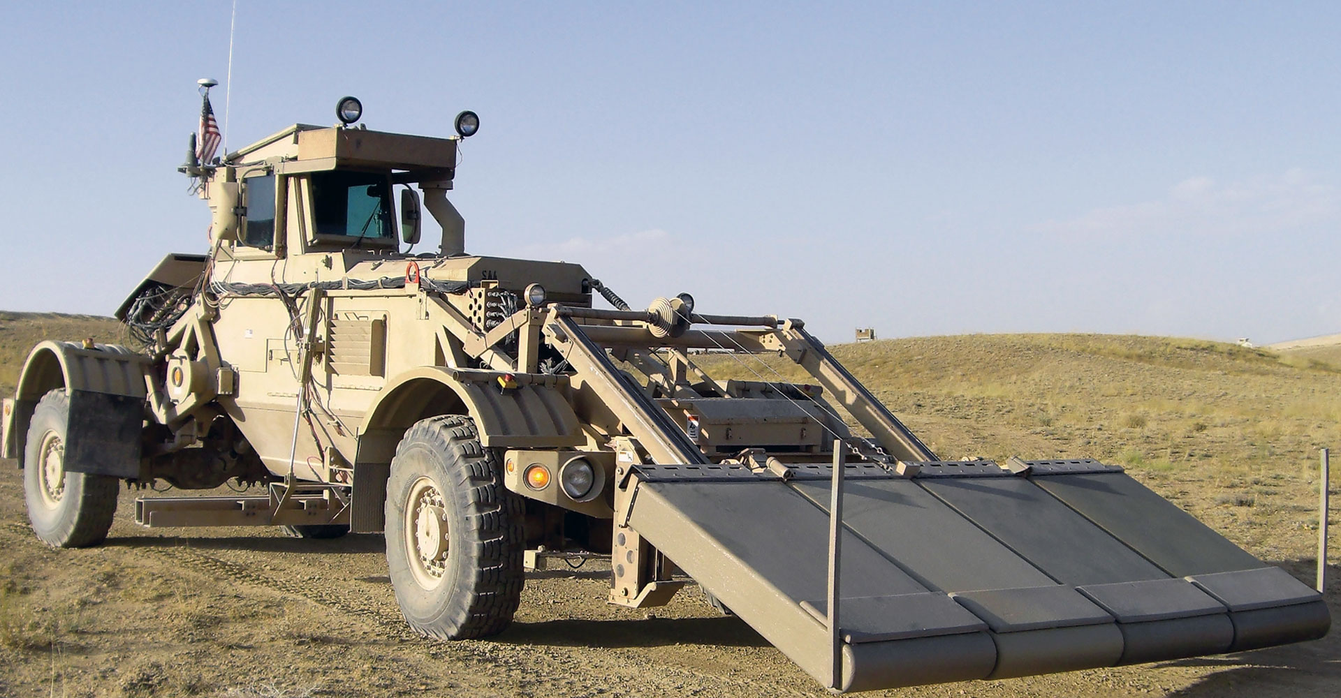
Husky Mounted Detection System (HMDS)
MISSION:
The Husky Mounted Detection System (HMDS) is a counter explosive hazard system that provides standoff detection and marking of explosive hazard threats in support of area access route clearance operations.
DESCRIPTION:
The Husky Mounted Detection System (HMDS) is a counter explosive hazard system that provides standoff detection and marking of metallic and low-metallic shallow-buried antitank landmines, trigger mechanisms, improvised explosive devices (IEDs), and in support of route clearance operations. Initially fielded as a Quick Reaction Capability (QRC), it is still deployed in theater.
SYSTEM INTERDEPENDENCIES:
- N/A
PROGRAM STATUS:
- Operations and Sustainment
PROJECTED ACTIVITIES:
- Operations and Sustainment
Husky Mounted Detection System (HMDS)
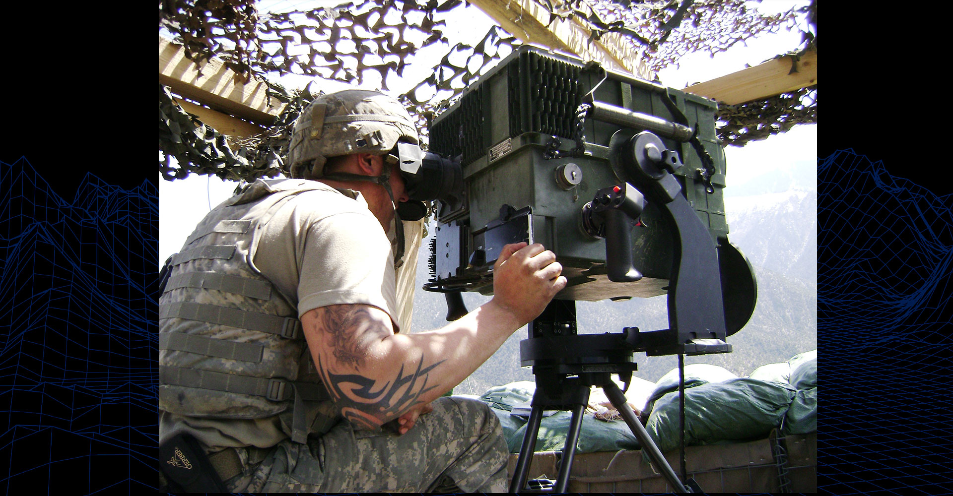
Long Range Advanced Scout Surveillance System (LRAS3/FS3)
MISSION:
The LRAS3 is a multi-function line of sight target acquisition common sensor suite which provides real time target detection, recognition, and identification capability. The LRAS3 automatically determines far target location coordinates for any target ranged by the operator. The LRAS3 enables information superiority by interfacing with the FBCB2 to provide target acquisition and FTL information to units and forces on the lower tactical network. The LRAS3 operates in both stationary vehicle mounted and in a dismounted configuration. The LRAS3 is a key enabling technology and a unit Pacing Item to Infantry Brigade Combat Teams (BCTs).
DESCRIPTION:
The LRAS3 provides 19D Cavalry Scouts in Armored, Infantry, and Stryker BCTs with a long-range surveillance and reconnaissance capability 24 hours a day in all weather conditions and battlefield environments while remaining outside the threat detection range. The LRAS3 Fire Support Sensor System variant provides target designation capabilities to Fires Support elements within BCT formations. The FS3 variant provides Fires Support Vehicles within BCT formations with the capability to provide both direct and indirect artillery support to maneuver elements.
SYSTEM INTERDEPENDENCIES:
- Mounted version of the LRAS3 is on the Stryker Armored vehicles, M707 Knight, and M1200 Armored Knight Support Vehicle
PROGRAM STATUS:
- Sustainment
PROJECTED ACTIVITIES:
- Sustainment
Long Range Advanced Scout Surveillance System (LRAS3/FS3)
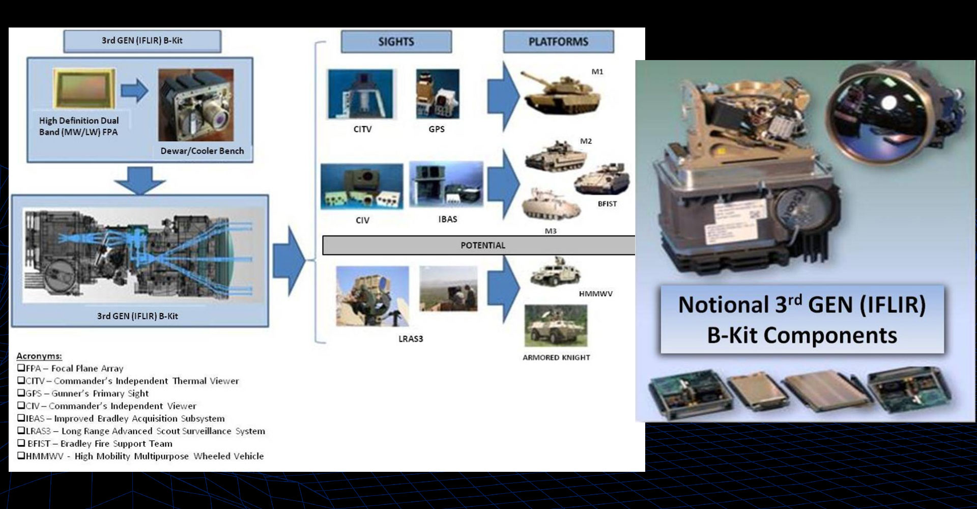
Third Generation Forward Looking Infrared (3GEN FLIR)
MISSION:
The 3GEN FLIR program Incorporates High Definition (HD) dual band Mid-Wave Infrared/Long-Wave Infrared (MWIR/LWIR) sensing technology for reconnaissance, surveillance and target acquisition capabilities in day-night and degraded battlefield environments. The 3GEN FLIR B-Kit will replace the 2GF B-Kit.
DESCRIPTION:
The 3GEN FLIR program incorporates dual band technology advances into a common B-Kit for integration across multiple platform sensor applications, enabling combat forces to realize sensor overmatch through increased information fidelity, situational awareness (SA), lethality, survivability, and freedom of maneuver/action in the execution of operations across the full spectrum of conflict.
SYSTEM INTERDEPENDENCIES:
- 3GEN FLIR will be on the Abrams Tank platform
PROGRAM STATUS:
- Engineering and Manufacturing Development
PROJECTED ACTIVITIES:
- Low-Rate Initial Production (LRIP)
Third Generation Forward Looking Infrared (3GEN FLIR)
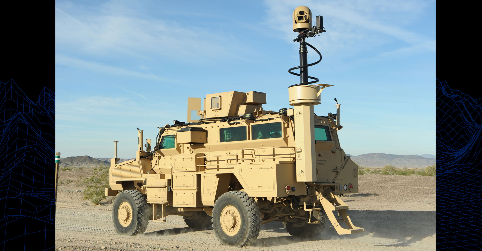
Vehicle Optics Sensor System (VOSS)
MISSION:
The VOSS provides Army Combat Engineers; Chemical, Biological, Radiological and Nuclear (CBRN) and Explosive Ordnance Disposal (EOD) personnel with a vehicle mounted standoff optical capability to visually scan, identify and locate suspected Explosive Hazards, Improvised Explosive Device (IEDs) and personnel while the vehicle is stationary or on the move.
DESCRIPTION:
The VOSS is a remotely-controlled, gyro-stabilized, telescoping, high-resolution, zoom-capable multi sensor (daylight camera, night-vision camera, thermal-imaging camera) surveillance system that uses existing commercial camera technology to provide a vehicle mounted standoff IED detection capability. It is installed on Medium Mine Protected Vehicle (MMPV) Type I (Panther & recapitalized RG33L+) and Type II (recapitalized RG-31) vehicles.
SYSTEM INTERDEPENDENCIES:
- VOSS is mounted on mine resistant ambush-protected vehicles
PROGRAM STATUS:
- Production and Deployment
PROJECTED ACTIVITIES:
- Production and Deployment; Transition to Sustainment