
")


MISSION:
Develop, acquire, field, and supply life cycle support to tactically relevant aerial intelligence, surveillance, and reconnaissance (ISR) sensors that maintain battlespace awareness and superiority.
VISION:
Deliver the Army’s premier aerial ISR sensors enabling timely dissemination of intelligence products to meet current and future Soldier needs. Engage necessary stakeholders and mission partners across the Army Intelligence Community to enable critical reach processing, exploitation, and dissemination (PED) operations.
End State: Products support the Soldier with actionable intelligence in the right place, right time, and at the best value for our nation.
DESCRIPTION:
Deliver the Army’s premier aerial ISR sensors enabling timely dissemination of intelligence products to meet current and future Soldier needs.
Engage necessary stakeholders and mission partners across the Army Intelligence Community to enable critical reach PED operations.
Fulfill urgent operational needs by quickly providing Soldiers the Quick Reaction Capabilities and Programs of Record needed to maintain battle space awareness and superiority.
MS. JULIE ISAAC

Ms. Julie Isaac assumed responsibilities as the Project Director for Sensors Aerial Intelligence (PD SAI) in May 2024. She leads an organization responsible for the delivery of the Army’s premier aerial intelligence, surveillance, and reconnaissance (ISR) sensors to enable the timely dissemination of intelligence products to meet current and future Soldier needs.
Ms. Isaac started her career in acquisition as a statistician, working on multiple assignments such as Program Office Estimates, Analysis of Acquisition and Business Case Analysis for numerous Acquisition Category (ACAT) II and ACAT III acquisition programs. She pursued many growth opportunities as a junior employee by engaging in opportunities within the Program Office in Contracts and Program Analysis within both Program Executive Office Command Control Communications-Tactical (PEO C3T) and PEO Intelligence, Electronic Warfare and Sensors (IEW&S) for ACAT I, II, and III programs.
In 2016, she started an assignment as Program Analyst for Program Manager Electronic Warfare and Integration where she guided the Business Management Division team through the growth to an ACAT I Major Automated Information System. This undertaking included the successful completion of an Army Cost Position, a Milestone B for Capability Drop 2 and a Limited Deployment Decision for Capability Drop 1.
Ms. Isaac was then selected as the Business Management Division Chief for PD SAI where she led a team providing guidance and oversight of the fiscal laws and regulations for the programs to execute funding and contracts through the yearly Program Plans Budget and Execution (PPBE) cycle. She spent a year of her time at PD SAI as Acting Deputy Project Director (DPD) during which she ensured seamless continuity of internal operations and maintained stakeholder relationships and engagements. She was awarded a C5ISR Top Ten Outstanding Personnel of the Year Award in 2021 for her time as Acting DPD.
In February 2022, she was selected as Deputy Project Manager for Position, Navigation, and Timing (PM PNT), where she led two of the Army’s modernization priorities through successful Milestone C and Initial Operational Test and Evaluation events. During her stead at PM PNT, the Alternative Navigation (ALTNAV) program received a successful Acquisition Shaping Panel and received verbal approval to enter program initiation.
Ms. Isaac assumed responsibilities as the DPD SAI in March 2024. As the DPD, she was responsible for manned and unmanned aerial sensor capabilities for the U.S. Army and other users.
Ms. Isaac’s passion for mentoring, training the acquisition workforce, and advocacy for women led to her being nominated for and receiving the APG Federal Women’s Program for Outstanding Women of the Year in 2023. She holds additional awards that include two Meritorious Civilian Service Medals, a Civilian Service Commendation Medal, and an Achievement Medal.
Ms. Isaac holds a Bachelor of Science in Mathematics and Economics. She is a U.S. Army Acquisition Corps Member, DoD Financial Management Level III certified with Defense Acquisition Workforce Improvement Act (DAWIA) certifications in both Business Financial Management and Program Management Career Fields.
MS. TRACY NOVOA

Ms. Tracy Novoa became the Deputy Project Director (DPD) for PD Sensors-Ariel Intelligence (SAI), Aberdeen Proving Ground, Maryland, in June 2024. In her role as DPM, Ms. Novoa provides guidance and leadership for the SAI workforce of more than 127 personnel supporting 3 Army acquisition programs and multiple supporting efforts.
Ms. Novoa previously served as the Test and Evaluation Director for Project Management Office Positioning, Navigation and Timing (PM PNT) where she managed testing and the technical development and evaluation of Army Modernization Priority, DOT&E oversight, ACAT II/ACAT III and Middle Tier Acquisition programs. Ms. Novoa began her career in industry as an Associate Mechanical Engineer at Accudyne Systems, Inc based out of Newark, DE in 2007 and after six years was promoted to Lead Project Engineer/Program Manager. During her 14 year tenure at Accudyne, Ms. Novoa focused her energy on solving complex physics problems, developing custom automation and manufacturing solutions, and building coalitions within the Aerospace and Department of Defense Industries. In 2018, Ms. Novoa accepted a position with US Army Test and Evaluation Command (ATEC) at the Aberdeen Test Center (ATC), Aberdeen Proving Ground, MD in the Tactical Vehicles Division serving as lead test officer for the M88A2 program, Infantry Squad Vehicles (ISVs), and Army Future’s Command Expedient Leader Follower Program. In 2020, she began her Army Acquisition Career within PEO IEW&S, PM PNT as the Test and Evaluation Lead for PM Dismounted PNT.
Ms. Novoa holds a Master’s of Science in Mechanical Engineering from Johns Hopkins University and a Bachelor’s of Science in Mechanical Engineering from The University of Delaware.Ms. Novoa is married to Jonathan Novoa, an Associate Chief for DEVCOM Power Division, and has two sons Tristan and Connor.
LATEST PM SAI NEWS
AERIAL ENHANCED RADARS, OPTICS & SENSORS (AEROS)
MEDIUM ALTITUDE RECONNAISSANCE & SURVEILLANCE SYSTEM (MARSS)
MULTI-DOMAIN SENSING SYSTEM (MDSS)
Programs
AERIAL ENHANCED RADARS, OPTICS & SENSORS (AEROS)
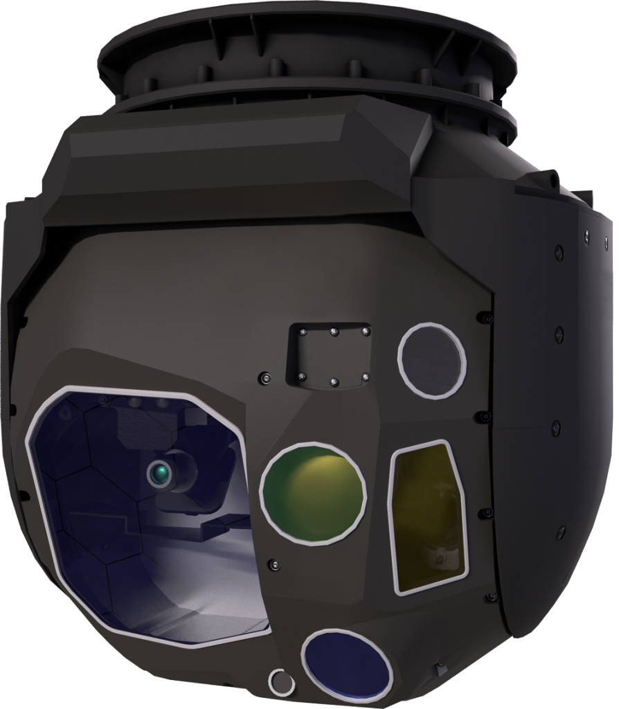
Common Sensor Payload (CSP)
MISSION:
The CSP is an electro-optic/infrared/laser designator (EO/IR/LD) sensor that provides reconnaissance, surveillance, target acquisition (RSTA), and intelligence gathering capabilities to the MQ-1C Gray Eagle uncrewed aircraft system (UAS) in support of battlefield commanders.
DESCRIPTION:
- The CSP provides near real-time imagery for detection and classification of targets/threats for battlefield commanders with a day/night imaging sensor and laser designation, pointing, target marking, and spot tracking for aerial intelligence.
- The upgraded CSP version 3 (v3) is currently in production with the new Target Location Accuracy (TLA) capabilities, which will provide automated target coordinate mensuration done in seconds versus minutes/hours to allow for near-real time engagements with coordinate seeking weapons, significantly improving the sensor-to-shooter kill chain.
SYSTEM INTERDEPENDENCIES:
- The CSP mounts onto the MQ-1C Gray Eagle and is required for the Gray Eagle to execute its mission in support of battlefield commanders.
- Additional system interdependencies include the MQ-1C Ground Control Station (GCS), other sensors installed on the MQ-1C Gray Eagle aircraft, MQ-1C-provided communications pathways for transmitting full-motion video and associated target data, and battle command systems.
PROGRAM STATUS:
- Currently undergoing Pre-planned Product Improvement (P3I) to add TLA and Short-Wave Infrared (SWIR) capabilities. CSP v3 is currently in production by the prime contractor.
- Post-Milestone C/Full Operational Capability, Transitioned to Organic Sustainment
PROJECTED ACTIVITIES:
- FY25: CSP Consolidated Software development and test; First production CSP v3 delivery
- FY26: Delivery to Gray Eagle original equipment manufacturer for mounting on the production line and subsequent fielding.
Common Sensor Payload (CSP)
Launched Effects (LE) Payloads
MISSION:
To deliver high-quality, cost-effective, multi-mission payloads for LE across all variants of uncrewed aircraft systems (UASs).
DESCRIPTION:
A family of systems (FoS) approach for all UAS/LE to allow flexibility in variants and versions across multiple platforms and payloads.
SYSTEM INTERDEPENDENCIES:
- Payloads are dependent on specific air vehicle size, weight, and power requirements that will limit the capabilities each size vehicle can have installed
PROGRAM STATUS:
PdM AEROS is currently teaming with PM Uncrewed Aviation Systems (PM UAS) from PEO Aviation to execute a Technology Maturation Initiative (TMI) to mature multi-function capability payloads.
- Payload requirements and capabilities have been modified and incorporated into the in the recently approved LE Abbreviated Capabilities Development Document (A-CDD)
- Pending Memorandum of Agreement between PEO AVN and PEO IEW&S for LE payloads
PROJECTED ACTIVITIES:
PdM AEROS supports PM UAS and the LE community by providing payloads assistance on all payloads for the LE FoS.
- PdM AEROS has reached across the S&T communities and other PEOs/JPEOs to provide the “best of breed” capabilities
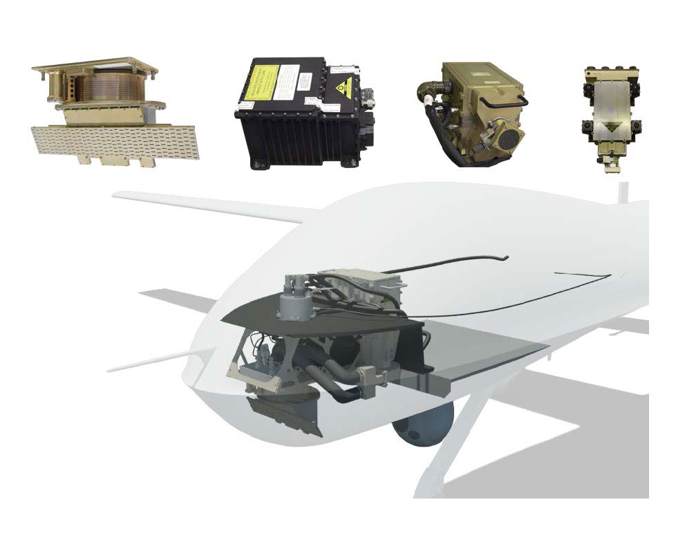
Small Tactical Radar Lightweight (STARLite)
MISSION:
STARLite is a synthetic aperture radar/ground moving target indicator, dismount moving target indicator (SAR/GMTI/DMTI) system, which is a lightweight, high performance, all-weather, multi-functional radar sensor.
DESCRIPTION:
- Payload is capable of on-board processing and transmission of near-real-time imagery and target detection data to the Universal Ground Control Station (UGCS) via a digital data link
- SAR and MTI data can be exploited in the PED and/or the Ground Control Station-Element in the UGCS
- Provides battlefield commanders increased situational awareness through wide area surveillance, imaging of stationary targets, and detection/tracking of moving targets
SYSTEM INTERDEPENDENCIES:
- STARLite and the Common Sensor Payload (CSP) cross-cue on the MQ-1C UAS Gray Eagle
- STARLite provides high-resolution spot mode imagery and high-resolution strip mode imagery up to 20 kilometers
PROGRAM STATUS:
- Post-Milestone C / FOC, Transitioned to Organic Sustainment
PROJECTED ACTIVITIES:
- FY25: Provide STARLite refresher/software update training for units
- FY25: Complete delivery of STARLite A-Kits to all Gray Eagle units
Small Tactical Radar Lightweight (STARLite)
MEDIUM ALTITUDE RECONNAISSANCE & SURVEILLANCE SYSTEM (MARSS)
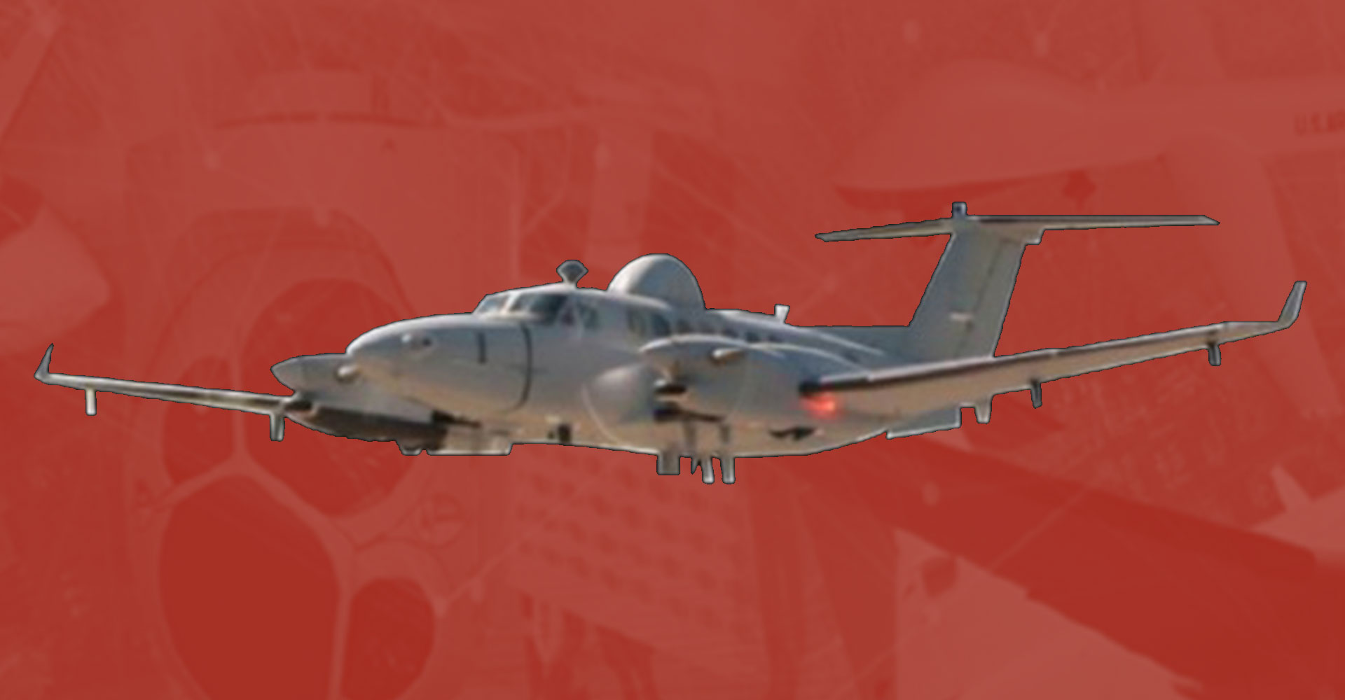
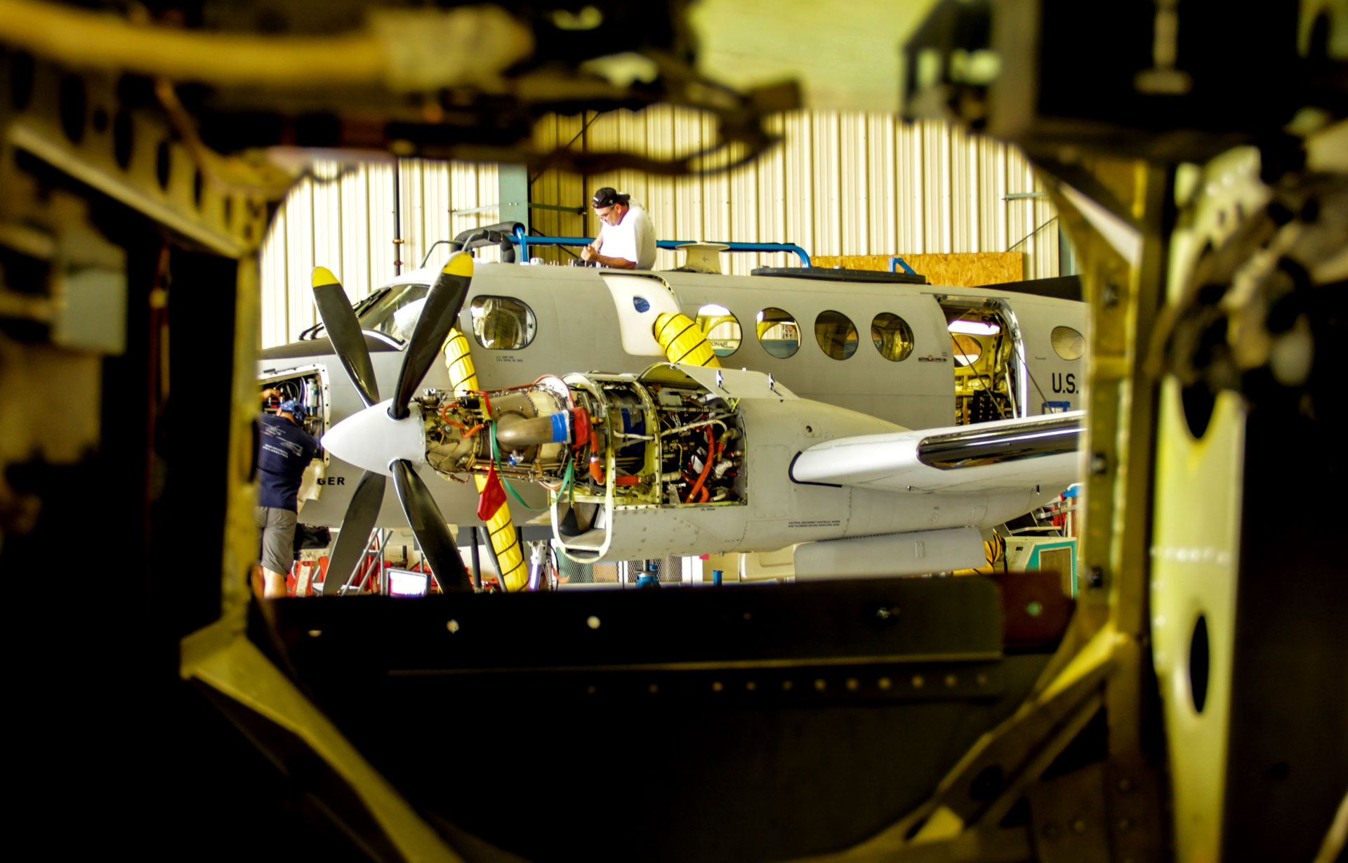
Enhanced Medium Altitude Reconnaissance and Surveillance System (EMARSS)
MISSION:
EMARSS is the Army’s current-generation C-12 based, direct support, manned airborne intelligence collection, processing, and targeting support system. It provides a persistent capability to detect, locate, classify/identify, and track surface targets with a high degree of timeliness and accuracy.
DESCRIPTION:
EMARSS provides rapid cross-cueing of multiple on-board sensors to enable timely target confirmation and positive identification of mobile, fleeting targets in direct support brigade combat team operations as well as general support to higher echelon and coalition forces across the full range of military operations. The EMARSS program’s flexibility, endurance, sensor capability, communications architecture, and PED provides critical, near real-time support to multiple combatant commands.
EMARSS aircraft are assigned to the U.S. Army Intelligence and Security Command’s (INSCOM) Aerial Exploitation Battalions (AEBs) providing aerial ISR support to combatant commanders. The Army Acquisition Objective for EMARSSS is 36 systems, with an Army Procurement Objective of 24, to include the following variants: eight EMARSS-Geospatial Intelligence (EMARSS-G); four EMARSS-Vehicle and Dismount Exploitation Radar (VADER) (EMARSS-V); eight EMARSS-Multiple Intelligence (EMARSS-M); and four EMARSS-Signals Intelligence (EMARSS-S).
SYSTEM INTERDEPENDENCIES:
- EMARSS intercepts, identifies, locates, and reports threat special communications signals emitters. The system provides real-time downlink sensor-to-shooter connectivity to the Soldier via a common data link (CDL) and tactical comms links. Beyond-line-of-sight, net-centric, off-board analysis, and reporting reduces deployed footprint and sustainment. EMARSS sensor collection data also feeds the National Intelligence Community and supports the Army’s PED Center of Excellence mission requirements
PROGRAM STATUS:
- Post Milestone C:
- Operations and Sustainment; Completing communications intelligence sensor technology refresh; Divestment ongoing
PROJECTED ACTIVITIES:
- FY25: Divest remaining EMARSS aircraft
Enhanced Medium Altitude Reconnaissance and Surveillance System (EMARSS)
Guardrail Common Sensor (GRCS)
MISSION:
The GRCS is an RC-12X fixed-wing aircraft, which hosts communications intelligence and electronic intelligence sensors. It provides a persistent capability to detect, locate, and classify/identify critical targets with a relevant degree of timeliness and accuracy.
DESCRIPTION:
Originally a Cold War system built for Indications and Warnings against adversaries in both European and Pacific Theaters of Operation, the GRCS provides near peer capability and anti-access/area denial standoff. The Guardrail RC-12X significantly improves the system’s tactical irregular warfare capability, by collecting low-, mid-, and high-band radio signals; identifying, classifying; determining source location; and providing near-real-time reporting, ensuring information dominance to commanders.
The GRCS is assigned to two U.S. Army Intelligence and Security Command’s Aerial Exploitation Battalions, providing aerial ISR support to combatant commanders. In accordance with the Army’s aerial ISR 2020 strategy, the Army’s Acquisition Objective/Army’s Procurement Objective (AAO/APO) is 19 RC-12X; seven fielded to the 3rd Military Intelligence (MI) Battalion (BN); seven fielded to the 204th MI BN, and five pilot trainers to support Force Generation. The five trainers are not equipped with Primary Mission Equipment.
SYSTEM INTERDEPENDENCIES:
- The GRCS intercepts, identifies, locates, and reports threat special communications signals emitters. The system provides real-time downlink sensor-to-shooter connectivity to the Soldier via a common data link (CDL) and tactical comms links. Net-centric, off-board analysis and reporting reduces deployed footprint and sustainment. The GRCS sensor collection data also feeds the National Intelligence Community and supports the Army’s PED Center of Excellence mission requirements
PROGRAM STATUS:
- Post Milestone C:
- Operations and Sustainment; Completing signals intelligence sensor technology refresh; Divestment ongoing
PROJECTED ACTIVITIES:
- FY25: Divest remaining GRCS and GSSM aircraft
Guardrail Common Sensor (GRCS)
MULTI-DOMAIN SENSING SYSTEM (MDSS)
Airborne Reconnaissance & Electronic Warfare System (ARES)
MISSION:
ARES is a manned contractor-owned, contractor-operated (COCO) proof of concept aerial ISR technical demonstrator jet, delivering modernized sensor capabilities against near-peer threats and adversaries, operating in the U.S. Pacific Command area of responsibility.
DESCRIPTION:
The objective for the aerial ISR technical demonstrator includes:
- The evaluation of electronic intelligence, communications intelligence, and electronic warfare/attack and cyber effects using a COCO jet that exceed capabilities of the Army’s current programs of record
- Assessing performance of modern sensors flown at high altitudes with the ability to conduct deep sensing during exercises and deployment
- Informing future aerial ISR modernization priorities
- Refining the capability gaps for expeditionary PED
SYSTEM INTERDEPENDENCIES:
- U.S. Army Intelligence and Security Command PED network, PEO IEW&S sensors, Project Manager Intelligence Systems and Analytics Tactical Intelligence Targeting Access Node (TITAN) (future), PEO Aviation
PROGRAM STATUS:
- Aircraft operationally deployed
PROJECTED ACTIVITIES:
- FY25: Continued deployment and sensor upgrades
Airborne Reconnaissance & Electronic Warfare System (ARES)

Airborne Reconnaissance Targeting Exploitation Mission Intelligence System (ARTEMIS)
MISSION:
ARTEMIS is a manned contractor-owned, contractor-operated (COCO) proof of concept aerial ISR technical demonstrator jet, delivering modernized sensor capabilities against near-peer threats and adversaries, operating in the U.S. European Command area of responsibility.
DESCRIPTION:
The objective for the AISR technical demonstrator includes:
- The evaluation of electronic intelligence, communications intelligence, and electronic warfare/attack and cyber effects using a COCO jet that exceed capabilities of the Army’s current programs of record
- Assessing performance of modern sensors flown at high altitudes with the ability to conduct deep sensing during exercises and deployment
- Informing future aerial ISR modernization priorities
- Refining the capability gaps for expeditionary PED
SYSTEM INTERDEPENDENCIES:
- U.S. Army Intelligence and Security Command PED network, PEO IEW&S sensors, Project Manager Intelligence Systems and Analytics Tactical Intelligence Targeting Access Node (TITAN) (future), PEO Aviation
PROGRAM STATUS:
- Two aircraft operationally deployed
PROJECTED ACTIVITIES:
- FY25: ARTEMIS 1 & 2 continued deployment and sensor upgrades
Airborne Reconnaissance Targeting Exploitation Mission Intelligence System (ARTEMIS)

High Accuracy Detection and Exploitation System (HADES)
MISSION:
The MDSS HADES will be a multi-faceted sensing capability on higher altitude, longer endurance manned platforms (e.g., business jets) that can provide stand-off from enemy anti-access/area denial systems. HADES will address Army requirements for medium to high altitude aerial ISR capabilities to rapidly gain and maintain situational understanding, freedom of maneuver, overmatch, and decision advantage in Multi-Domain Operations.
DESCRIPTION:
- Flexible and integrated platforms, payloads, data transport, and enhanced analysis capabilities
- Ability to conduct deep sensing to recognize, identify, track, and geo-locate targets
- Sensor-to-shooter links to shorten the kill chain and operate at the tempo and volume of large-scale ground combat operations
- Near-real-time products via on-board data processing using artificial intelligence and advanced data processing
- Initial capabilities will include electronic intelligence, communications intelligence, and synthetic aperture radar/moving target indicator sensing
- Follow-on capabilities will include cyber, electronic warfare, and air-launched effects
SYSTEM INTERDEPENDENCIES:
- U.S. Army Intelligence and Security Command PED network, PEO IEW&S sensors, Project Manager Intelligence Systems and Analytics Tactical Intelligence Targeting Access Node (TITAN) (future), PEO Aviation
PROGRAM STATUS:
- Program Type:
- Middle-Tier Acquisition Prototyping Program
- Requirement Trace:
- MDSS Initial Capabilities Document (ICD) validated by the Joint Requirements Oversight Council Memorandum (JROCM)-107-19 on 19 November 2019
- MDSS ICD U.S. Army Futures Command approved, 24 February 2020
- MDSS HADES Abbreviated Capability Development Document (A-CDD) validated by the Army Requirements Oversight Council Memorandum (AROCM) 20-20 on 26 August 2020
- Acquisition Phase: Pre-Milestone A
- Fielding Plan: TBD, Manning and equipment profiles pending analysis of alternatives decision
PROJECTED ACTIVITIES:
- FY25: Completion of sensor prototype development
- FY25: System prototype 1 integration
- FY25: System prototype 2 contract award and integration
High Accuracy Detection and Exploitation System (HADES)

High Altitude Extended-range Long-endurance Intelligence Observation System (HELIOS)
MISSION:
The Multi Domain Sensing System (MDSS), High-altitude Extended-range Long-endurance Intelligence Observation System (HELIOS) will provide deep sensing Intelligence, Surveillance and Reconnaissance Intelligence, Survellance and Reconnaissance (ISR) from high altitude (60-100,000 feet) against near-peer threats located one thousand miles or more beyond the Forward Line of Troops (FLOT).
DESCRIPTION:
HELIOS is just one component of the larger MDSS family of systems, which includes manned and unmanned ISR sensor-platform pairings arrayed in a self-healing network from low to high altitude through the entire depth of the future Multi Domain Operations (MDO) battlefield. As the Army transitions into an MDO capable and then an MDO ready force, HELIOS will serve as an essential component of the Waypoint and Aimpoint force.
Commanders require cross-domain solutions to penetrate anti-access/area denial defenses and precisely geolocate threat integrated air defense systems. The stratosphere is the final piece of the aerial domain that must be operationalized to complete the common operating picture across the entire depth of the future Multi Domain Operations (MDO) battlespace. Deep sensing from the stratosphere is a force multiplier for Joint, Army, and mission partners as it provides targetable data in near-real-time (NRT) for action by long-range Fires elements. Stratospheric sensors also increase commander’s situational understanding as it produces critical intelligence that is cloud discoverable by Joint All-Domain Command and Control systems and within the Army Command Post Computing Environment.
This deep sensing capability includes a mix of High-Altitude Intelligence, Surveillance, Reconnaissance (HA-ISR) sensors hosted on remotely piloted High Altitude Platforms (HAP) complemented by High Altitude Air Launched Effects (HA-ALE). These HA-ISR sensors will identify and develop land-based and maritime targets suitable for Long Range Precision Fires (LRPF) during conflict and provide persistent surveillance during competition on strategic areas of interest. In addition to its deep sensing capabilities, HA-ISR can conduct on-board data processing for rapid target recognition and reporting as well as a resilient architecture capable of functioning in disrupted, disconnected, intermittent and low-bandwidth (DDIL) environments.
SYSTEM INTERDEPENDENCIES:
- INSCOM Processing, Exploitation & Dissemination (PED) network, IEW&S sensors, IS&A TITAN (future), PEO Aviation
PROGRAM STATUS:
- Program Planning with program initiation in FY25
- Requirements Trace: HAP A-CDD and DS Annex
- (HAP-DS Validated 16 DEC 2022
PROJECTED ACTIVITIES:
- FY24: Continued sensor demonstrations
- FY24: Pre-contracting efforts
- FY25: Program initiation and contract award
High Altitude Platform-Deep Sensing (HAP-DS)
MISSION:
The MDSS HAP-DS will provide deep ISR from high altitude (60,000-100,000 feet) against near-peer threats located one thousand miles or more beyond the forward line of troops.
DESCRIPTION:
HAP-DS is just one component of the larger MDSS family of systems, which includes manned and unmanned ISR sensor-platform pairings arrayed in a self-healing network from low to high altitude through the entire depth of the future Multi-Domain Operations (MDO) battlefield. As the Army transitions into an MDO capable and then an MDO ready force, HAP-DS will serve as an essential component of the waypoint and aimpoint force.
Commanders require cross-domain solutions to penetrate anti-access/area denial defenses and precisely geolocate threat integrated air defense systems. The stratosphere is the final piece of the aerial domain that must be operationalized to complete the common operating picture across the entire depth of the future MDO battlespace. Deep sensing from the stratosphere is a force multiplier for Joint, Army, and mission partners as it provides targetable data in near-real-time for action by long-range Fires elements. Stratospheric sensors also increase a commander’s situational understanding as it produces critical intelligence that is cloud discoverable by Joint All-Domain Command and Control systems and within the Army Command Post Computing Environment.
This deep sensing capability includes a mix of High-Altitude ISR (HA-ISR) sensors hosted on remotely piloted HAP complemented by High Altitude Air Launched Effects. These HA-ISR sensors will identify and develop land-based and maritime targets suitable for Long Range Precision Fires during conflict and provide persistent surveillance during competition on strategic areas of interest. In addition to its deep sensing capabilities, the HA-ISR sensors can conduct on-board data processing for rapid target recognition and reporting as well as a resilient architecture capable of functioning in disrupted, disconnected, intermittent and low-bandwidth environments.
SYSTEM INTERDEPENDENCIES:
- U.S. Army Intelligence and Security Command PED network, PEO IEW&S sensors, Project Manager Intelligence Systems and Analytics Tactical Intelligence Targeting Access Node (TITAN) (future), PEO Aviation
PROGRAM STATUS:
- Program Planning with program initiation in FY25
- Requirements Trace: HAP Abbreviated Capability Development Document (A-CDD) and DS Annex (HAP-DS Validated 16 December 2022)
PROJECTED ACTIVITIES:
- FY25: Sensor prototype procurements
- FY25: Continued sensor demonstrations
High Efficiency RF Monitoring and Exploitation System (HERMES)
MISSION:
Provides Multi-Domain Operations (MDO) capable sensing against near-peer threats in highly contested electromagnetic, cyber, and Denied, Disconnected, Intermittent, and Limited (DDIL) environments
DESCRIPTION:
HERMES will provide MDO capable sensing against near-peer threats in highly contested electromagnetic, cyber, and Denied, Disconnected, Intermittent, and Limited (DDIL) environments. HERMES is employed on aerial ISR systems providing detection, identification, and precision geolocation of threats for targeting by the Army’s Integrated Fires System (IFS) through the entire depth of the future MDO battlefield.
HERMES provides multi-platform signals intelligence (SIGINT) for the aerial layer. The software defined radios collect on threat signatures in all theaters. HERMES sensors use secure, cyber resilient, assured data transport to feed artificial intelligence/machine learning (AI/ML) enabled processing, exploitation, and dissemination (PED) functions. HERMES relies on an integrated approach across the Multi-Domain Sensing System family of systems with the intent of converging capabilities from multiple domains, the electromagnetic spectrum, and the information environment supporting the MDO Force’s ability to achieve overmatch.
HERMES mitigates SIGINT collection gaps and provides the means to outpace adversary technology by advancing U.S. capabilities to the edge of technological innovation and operational relevance. It supports Commanders across all phases by revealing adversary capabilities, actions, and intent, providing targetable information, and satisfying information needs as the Joint Force transitions back to competition. The HERMES open architecture design and distributed network approach supports convergence of intelligence, electromagnetic warfare, cyberspace, and fires capabilities available to multi-domain formations. Ultimately, it increases Army relevance in the Joint fight and is a vital component of an MDO ready intelligence enterprise.
SYSTEM INTERDEPENDENCIES:
- HERMES interdependencies are still to be determined, but currently envisioned initially as a capability for the MQ-1 Gray Eagle uncrewed aircraft system (UAS)
PROGRAM STATUS:
- Requirement is in draft. Supporting the Army Capability Manager for Intelligence Sensors (ACM-IS) and intel community to develop and refine aerial unmanned SIGINT requirements
PROJECTED ACTIVITIES:
- Requirement pending Army approval – pre-requirement coordination with ACM-IS