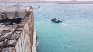
Photo By John Higgins | SHEMYA ISLAND, Alaska — Staff Sergeants Jacob Feyers, Brent Evans, Shane Van Alstyne, and Michael Singley, on the boat, of the 7th Engineer Dive Detachment, 84th Engineering Battalion out of Joint Base Pearl Harbor, Hawaii, set out with equipment provided by Product Director Combat Terrain Information Systems, including the Instrument Set, Reconnaissance and Surveying toolset, known as ENFIRE and the Multi-functional Assessment Reconnaissance Vessel II, or MARV II, in a mission to survey, collect the required data and ensure the future work that needs to be planned for the much calmer summer season and the extensive repair operations will have as much information as they need. Construction, design and even navigation assets will all be able to access and use use the collected data to maximize their operations. U.S. Army Photo/1st Lt. Ander Thompson
Shemya Island is also subject to weather conditions that are beyond hostile, indeed almost alien, for a majority of the year. Ice fog, freezing fog and freezing sea spray are all common conditions on Shemya, and in early May, the high temperature for the day will average at around 34 degrees Fahrenheit, with an average wind speed of 20 miles per hour. The water around the island is often some of the roughest in that area of the world, with swells reaching 20 feet or more. With so little vegetation – no trees at all – the islands black sand beaches are constantly loosing and gaining sediment mass from those waves for most of the year.
Any mission on Shemya could be said to challenging.
In mid-February, a large storm cell hit Eareckson, causing extensive damage, impeding future logistical operations; most supplies delivered to island happen by ship and those docks were damaged by this storm cell.
US Army Pacific Command mobilized the 7th Engineer Dive Detachment, 84th Engineering Battalion out of Joint Base Pearl Harbor, Hawaii in response to help investigate the damage and provide repair support.
With those challenges in mind, Capt. Ayman Andrews, Commander, 7th Engineering Dive Detachment, set out looking for resources for this mission. He soon found himself calling George Ohanian, who is dual hatted as Product Director Combat Terrain Information System (PD CTIS) and as Branch Chief Military Engineering and Survey Support for the U.S. Army Geospatial Center (AGC).
The piece of equipment Andrews needed was the Multifunctional Assessment Reconnaissance Vessel II or MARV II produced in a collaborative manner by Product Director Combat Terrain Information System (Pd CTIS) under the Program Executive Office Intelligence, Electronic Warfare and Sensors (PEO IEW&S). The MARV II brings new capabilities and improves upon existing Commercial Off the Shelf (COTS) capabilities for military reconnaissance like the Light Detection and Ranging (LIDAR) which is a remote sensing method that uses light in the form of a pulsed laser to measure variable distances, Multi-Beam Echo-Sounders, sub-Centimeter GPS accuracy for precise position location on the water and HD Video that gives any data consumer clear views below the surface.
With LIDAR and Multi-Beam working simultaneously, the MARV II can detect objects above and below the water surface as well as identify sub-surface conditions that would have otherwise impeded or negated ingress/egress operations and with data 3D models of surfaces can be generated.
“I called him to discuss the MARV II fielding” said Andrews. “I offhandedly mentioned ‘We got this mission, it would great if we actually had (the MERV II) and the next thing you know he helped piece everything together, talked to relevant parties and two or three days later I had a portion of the system at my doorstep. Pretty impressive.”
Ohanian’s dual hat status puts him in a unique position to support operations. As a Product Director under Program Executive Office Intelligence, Electronic Warfare & Sensors (PEO IEW&S), he is in charge of how capabilities are developed and fielded to meet Programs of Record objectives. However, as the Branch Chief of Military and Civilian Engineering and Survey, for Army Geospatial Center (AGC) he also has a high level of understanding of what kind of existing equipment can be applied to meet complex and unique problems specific to his field.
“I sit in a unique position where I am responsible for Program Management of a sanctioned ACAT IV (previously ACAT III) program under the oversight of Program Executive Office Intelligence, Electronic Warfare & Sensors” said Ohanian. “I also serve as a Branch Chief in the Army Corps of Engineers (USACE) responsible for multiple Civilian programs directly funded in the annual budget by Congressional actions. The ‘dual hatted’ aspect allows me the ability to cross collaborate and cross pollenate (where applicable) expertise and resources to improve the capabilities of my end users. Civilian programs under the auspice of USACE are managed extremely different than programs that fall under the Army Acquisition process thus consistently driving me to think about creative and more efficient solutions due to my interaction with diverse technical communities.”
“The call was on Monday, the [MARV II training] equipment was boxed up on Tuesday,” said Andrews. “It arrived at my office on Thursday and the guys trained on it after that.”
Matt Staley, also “dual hatted,” is in the same branch and field as Ohanian with focus on coastal areas and bodies of water surveying as well as support the USACE Survey Engineering & Mapping Technical Center of Expertise (TCX) in AGC.
“The MARV II is an expeditionary device: it provides a quick look at what’s down there.” said Staley. “Now the technology on it can be used for engineering purposes and the best thing that MARV can do is you put it in the water and see what obstacles are down there. You can see things that a diver can’t see from the pier, you will be able to establish absolute coordinates over those things before you even put a diver in the water.”
Staley worked closely with Andrews in the weeks before the deployment.
“That’s probably the most unique thing about this story, from my perspective,” said Andrews. “Relationships are so important and knowing which office, or who the experts out there are that can actually link a unit up with the technology that they need.”
Andrews went on to say that Soldiers in the field of Military Engineering can sometimes be “trapped” into thinking about only what they have in terms of equipment on hand, which was a reason for him to reach out and see what experts were “out there.” Thinking outside the box, he said, he found his way to Ohanian and Staley.
“I have been working those guys nonstop for the last week since they’ve been on site.” said Staley. “One of the things that they’re running into is weather conditions and you can’t fight weather conditions.”
“I grew up in Florida, if the water’s not 80 degrees I don’t want to get in it,” said Staley. “So I respect the divers for wanting to get into water that’s just barely above freezing, but if I can get a snapshot without having the divers in super cold water…if I can give them a better picture that reduces their search time, the less time they have to be in that super cold water, I feel that’s a mission won, mission accomplished.”
Using the MARV II components and other assets from PD CTIS portfolio, the 7th Engineer Dive Team was able to complete their survey, collect the required data and ensure the future work that needs to be planned for the much calmer summer season, allows for extensive repair operations without having to go back into the water. Construction, design and even navigation assets will all be able to access and use the collected data to maximize their operations.
“As we advance adoption of COTS technologies, we begin to realize the return on investments to multiple domains and the associated expediency we can bring to our mission sets.” said Ohanian. “Efforts like this showcase the ability to collaborate, leverage and modernize; rapidly and in real time, without investing large sums of money. Enablers are important and are foundational to multi-domain missions, regardless of their nature or objective.”

